
The SEA of JAPAN
The Sea is bounded on the east and south by the Japan islands, and on the west and north-west by the coasts of Korea and Russian Tartary is about 900 miles long, NNE and SSW, and 600 miles East and West, at its broadest part. Surrounded by land on all sides, this sea is only accessible by the following narrow passages:- To the south by the Korea strait, which connects it with the China sea; to the east by La Perouse and Tsugar straits, by which it communicates with the Pacific; and to the north by the gulf of Tartary, through which it communicates with the sea of Okhotsk by the gulf of Amur; this sea is, as far as is known, clear of rocks or dangers with the following exceptions: Liancourt Rocks, Matsu Sima (Dagelet island) and Waywoda Rock.
 TAKESHIMA (Liancourt Rocks)
The island was named after the French ship Liancourt, which discovered them in 1849; they were also called "Menalai and Olivutsa rocks" by the Russian frigate Pallas in 1854, and Hornet islands by H.M.S. Hornet in 1855. Koreans write them as "獨島," and Japanese fishermen call them "Yangko." They are a small group of islets located about eighty nautical ri from Oki Island and fifty nautical ri from Ulleungdo. They are made up of two islands and several small islets. The two islands are separated by a narrow waterway that is about a quarter ri wide and face each other from east and west. The west island, elevated about 410 feet above the sea, has a sugar-loaf form. The east island is relatively low and flat-topped. Most of the many small islets that surround them are flat rocks that bearly break the surface of the water. Most are big enough that a tatami of tens of jang could be laid out on them. Both islands are desolate and bare and are completely exposed to the wind and sea. There is not even one tree, only a little grass growing on the east island. The slopes of the islands are sheer precipices with some layering of rocks. There are many strange-looking caves, but they cannot be reached. These caves and the small islets are the breeding grounds for sea lions. The naval vessel Tsushima measured the depth of the waters around this island and said that it measured the depth at about fifty-eight fathoms at a spot about nine ryeon (0.9 nautical ri) from the southern tip of the east island. The island is a little dangerous because it is near navigation routes in the Sea of Japan.
Level Ground on the Island
There is no level ground on the island. Even though the waterway between the two islands is narrow, there are two or three flat, gravel patches there, but it would be difficult to avoid the assault of the waves. There is some flat land at the summit of the East Island, but there is no path leading up there. There is only a small patch of about three or four pyeong on the southern tip that blocks the northwesterly wind. The ridge spine of the West Island runs east to west. The slope of the upper half of the ridge is almost vertical, but the slope of the lower half is fairly gentle, so the cliffs can be reached. Therefore, if the hard rocks of this section can be excavated, then there would seem to be access to flat land sheltered from all wind except that from the east. As per above, there is absolutely no land on this island suitable for building a house. In November of the 37th year of Meiji (1904), it was said that the naval ship Tsushima found a small thatched hut for fishermen on the east island, but it was badly damaged by the wind and waves. It is said that each summer dozens of people come from Ulleungdo to this island to catch sea lions, and that they build a shelter and stay for about ten days each trip.
 Fresh Water
There is a cave on the southwest corner of the west island where a fair amount of water falls from the ceiling rocks, but it falls like rain, so it would be difficult to gather. There are a few springs along the midway section from the summit where water comes out, but they are so polluted by the excrement of the sea lions that they give off an odor, so they are absolutely not suitable for drinking. It is said that the fisherman who come here to catch sea lions use the water on this island for cooking, but the water they use for their tea is brought from somewhere else.
Location: According to the results of a survey by the American naval vessel New York in 1902, Takeshima is at a northern latitude of 37 degrees 9 minutes 30 seconds and an eastern longitude of 131 degrees 55 minutes.
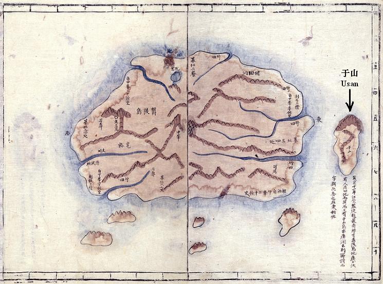
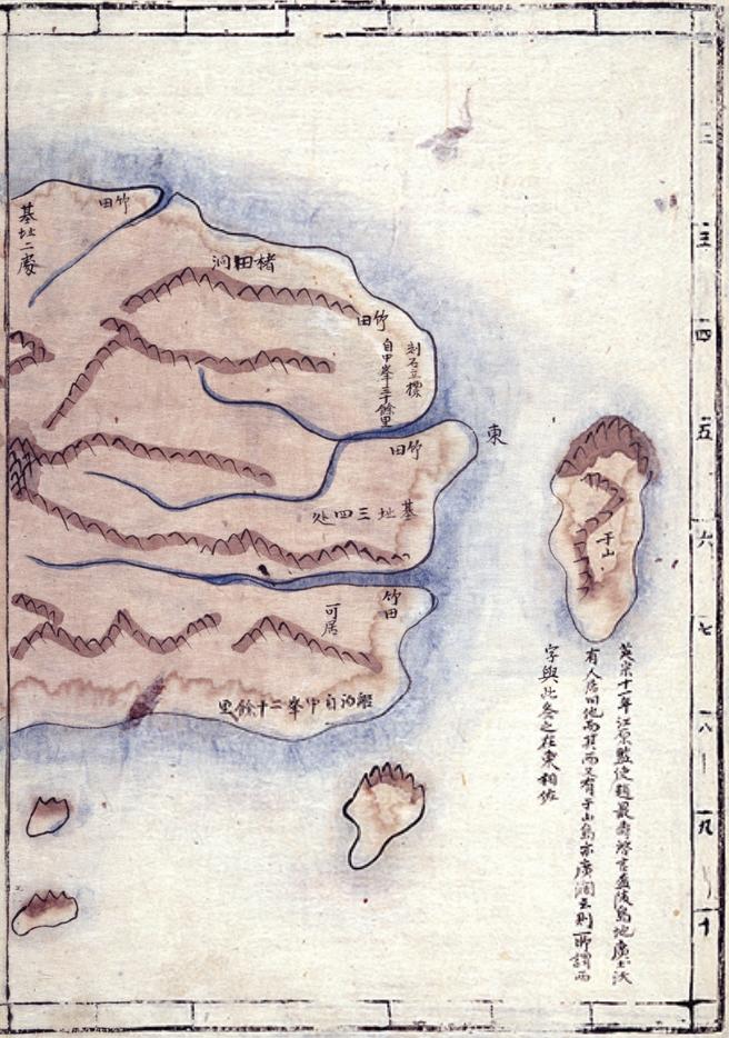
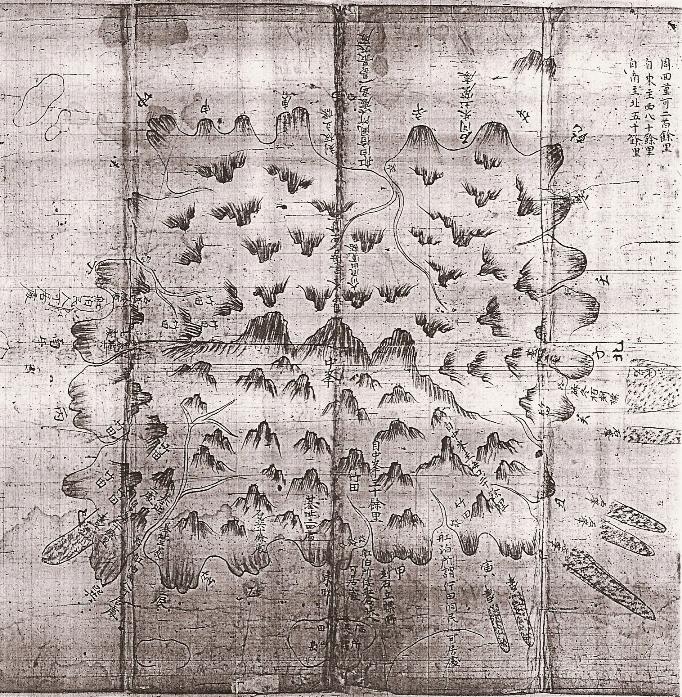
ULLEUNGDO or MATSUSHIMA (Dagelet island) 
It is semicircular island with a circumfererence of 18 nautical ri (浬 = nautical miles). The whole island is a collection of sharp conical hills, densely covered with trees, and supports an imposing peak in the center, at latitude 37° 30′ N. and longitude 130° 53′ E, that rises 3,208 shaku [feet]. Jukdo (Boussole Rock) is off the northeast shore, and about two and three-quarter nautical ri (浬) west-southwest of there is a rock where the water is two to three shaku (feet) deep. There are several rock islets offshore, especially, on the north and east sides. Some reach a height of 400 to 500 shaku (feet). They are all, like the island, steep, and the lead affords no warning, but none of them are more than a quarter of a mile from the cliffs, except for Boussole Rock, the largest, which is seven ren (cables) off the northeast shore. Hole Rock, off the north shore, is remarkable in that it has a large hole, or rather a natural archway, through it. On shore almost facing the rock is a smooth but very steep, sugar-loaf-shaped, bare granite rock that is about 800 shaku [feet] high. There is also a rock off Seal Point, at the southern tip. The sides of the island are so steep that soundings could only be obtained by going up almost to the base of the cliffs. Landing may be effected in fine weather, with difficulty, on some small gravel beaches, which occur at intervals, but the greater part of the island is quite inaccessible.
Korean residents were eight-five families with 260 people (175 men and 85 women), according to a survey at the end of December 1904. However, they increased to 110 families with 366 people (219 men and 147 women) by the end of June 1905. However, because these residents live next to the land they cultivate, their houses lie scattered, and there are only eight villages. The island has an island chief living there. The Japanese on the island are mainly woodcutters, carpenters, fishermen, sailors, and brokers. There are few other professionals. The Japanese population was 230 at the end of June 1905.
Climate
The hot and cold temperature differences on the island are not extreme. Southerly winds prevail from April to September while northerly winds prevail from October to March, with an especially strong northwest wind in November. They have snow from the end of October to the end of March. Sometimes there is still snow on the top of the mountain in May. The place is very healthy. There have been no epidemics, such as smallpox. The islanders attribute it to the good quality of the water.
Products
The island's main product is soybeans. Others include barley, millet, barnyard grass, and potatoes. The average soybean yield is 3,000 to 4,000 koku annually, while the other grains are raised for the consumption of the residents. There is usually no shortage of food. The fishing on the island is mainly for abalone. Each year a great deal of dried abalone is exported. A sea animal called a sea lion lives on an island called Takeshima (Liancourt rocks), which is located southeast of the island. The people on this island (Ulleungdo) began to catch them sometime about 1904. The hunting season is six months, from April to September. There are three boats that hunt for sea lions, and each boat catches an average of five. The abalone which the Japanese catch are caught by using two diving apparatuses and two steamships, and they say that the average catch per day is 1,130 kin. There are no wild animals on the island, but wildcats and pigeons are sometimes visible. As to the wood available, there are lots of zelkova and pine.
Exports and Imports
The island's exports include soybean, zelkova wood, dried abalone, sea lion skins, sea lion oil, and the squeezed dregs of sea lions. Its imports include polished rice, rice, sake (rice wine), shochu (clear distilled liquor), petroleum, sugar, cotton, cotton yarn, cotton fabrics, iron, straw bags, matches, ceramic ware, tableware, soy sauce, and somen (thin wheat noodles). The total export revenue from April to June in 1905 was 12,075 yen, and the total imports was 3,116 yen.
Available Products
In each village, a few chickens and eggs are available at cheap prices. Clear water is available at various places and and is said to be of good quality.
Korean Translation for the Takeshima Section
竹島(다께시마)(Liancourt rocks): 1849년 프랑스 선박 <리앙꼬르>가 이를 발견하여 라 칭하고 있으며, 1854년 러시아 함대 [팔라스]는 라고 하였다. 1855년 영국 함정 <호네트>는 이를 라고 부른다. 한인(韓人)들은 [獨島]라 쓰고, 일본어부들은 [リアンコ(리앙꼬)]島라고 한다. 이 섬은 일본해에 있는 하나의 작은 군도로 오끼국 섬에서 약 80해리, 울릉도에서 약 50해리 떨어진 곳에 위치하며 폭 4분지 1해리의 좁은 수도를 사이에 두고 동서로 대응하는 두 개의 섬과 그 주위에 있는 여러 작은 섬들로 구성된다. 서도(西島)는 해면상 높이가 약 410척이고 봉당(棒糖) 모양을 이루고 있고, 동도(東島)는 비교적 낮고 정상에 평탄한 땅이 있으며, 주위의 여러 조그만 섬들은 대개 편편한 암석으로 약간 수면에 노출되어 있고 그 크기는 대부분 수십 장의 다다미를 깔기에 충분하다. 두 섬 모두 황폐한 민둥산으로 해풍에 완전히 노출되어 있어서 한 그루의 수목도 없으며, 동도에 약간의 풀이 자랄 뿐이다. 섬 기슭은 단애절벽이고 약한 석층을 이루어 기이한 모양의 동굴이 많지만 오를 수가 없다. 이러한 동굴이나 조그만 섬들은 바다사자들의 서식지가 된다. 이 섬 부근 수심은 군함 對馬호가 동도 남단으로부터 북서방 약 9련(0.9해리) 떨어진 곳에서 58패텀의 수심을 얻었다고 한다. 이 섬은 그 위치상 일본해를 항해하는 선박의 항로에 가까워서 야간에 위험하다.
島上의 平地: 섬의 평지는 없고, 수도의 양측에 협소하지만 평탄한 자갈밭이 두 세 군데 있지만 모두 파도의 침습을 면하기 어렵다. 동도(東島)는 그 정상에 평탄한 땅이 있긴 하지만 이곳에 오르는 길이 없고, 오직 섬의 남단에 북서풍을 막아주는 3-4평의 작은 평지가 있을 뿐이다. 서도(西島)는 그 동서에 산등성이가 있는데, 그 상반부는 거의 직립해 있으나, 하반부는 경사가 꽤 완만해서 그 절반 부분까지 도달할 수 있고, 이 부근의 견암을 개착하면 동풍을 제외한 외풍을 막을만한 평지를 얻을 수 있을 것으로 보였다. 섬에는 위와 같이 가옥을 지을만한 땅이 전혀 없었고, 明治 37년(1904) 11월 군함 對馬호가 이 섬을 실사했을 때 동도에 어부용 작은 초가집이 있었으나 풍랑으로 심히 파괴되어 있었다고 한다. 매년 여름철이 되면 바다사자를 잡기 위해서 울릉도에서 넘어오는 사람이 수 십 명에 이르며, 그들은 섬에 조그만 거처를 만들어 매회 약 10일간 임시로 거주한다고 한다.
담수(淡水): 서도(西島)의 남서쪽 구석에 하나의 동굴이 있고, 그 천정 부분 암석에서 떨어지는 물의 양이 상당히 많지만, 빗물이 떨어지는 것 같아서 이를 받는데 어려움이 있다. 산 정상에서 중턱을 따라 몇 군데 물이 나오는 샘이 있으나 바다사자들의 분뇨로 오염되어 악취를 풍겨서 도저히 음료용으로는 적합하지 않다. 바다사자를 잡기 위해 오는 어부들은 이 섬에서 나는 물을 받아서 취사용으로는 쓰지만, 차로 마시는 물은 다른 곳에서 가지고 온 물을 사용한다고 한다.
위치(位置): 竹島(다께시마)는 1902년 실시한 미국 함정 <뉴욕>호의 검측에 의하면 북위 37도 9분 30초, 동경 131도 55분에 있다.
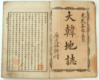
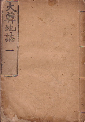 The Korean map below was included in the 1899 edition of the "Daehanjiji (大韓地誌), which was a Korean geography book written by Hyeon Chae (玄采). The book was published in two volumes, of which the cover of the first volume is pictured on the left. The book is comprised of thirteen chapters, excluding the introduction. The thirteen chapters describe the geography, history, economy, and other features of the thirteen provinces that made up Korea at the time. A Map of each province was also included in each chapter. The forward (序) of the book was written by Lee Gyu-hwan (李圭桓), who was the director of the editorial office for Korea's Ministry of Education (學部) at the time. The Korean map below was placed in the front of the book, before the introduction. The map is called the "Daehan Jeondo" (大韓全圖), which means "Complete Map of Korea."
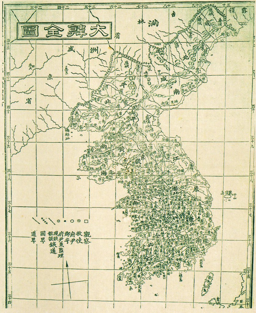


