竹島問題の歴史

30.12.08

1893 - "The Sea Chart of Hokkaido and Northeastern Islands(北洲及北東諸島)" plots Waywoda Rock far outside of Korean territory

Dec. 24th edition of Japan's San-in Chuo Shimpo(山陰中央新報) (cache) reported that the new evidence which debunks pro-Korean's distorted claim was found, again.

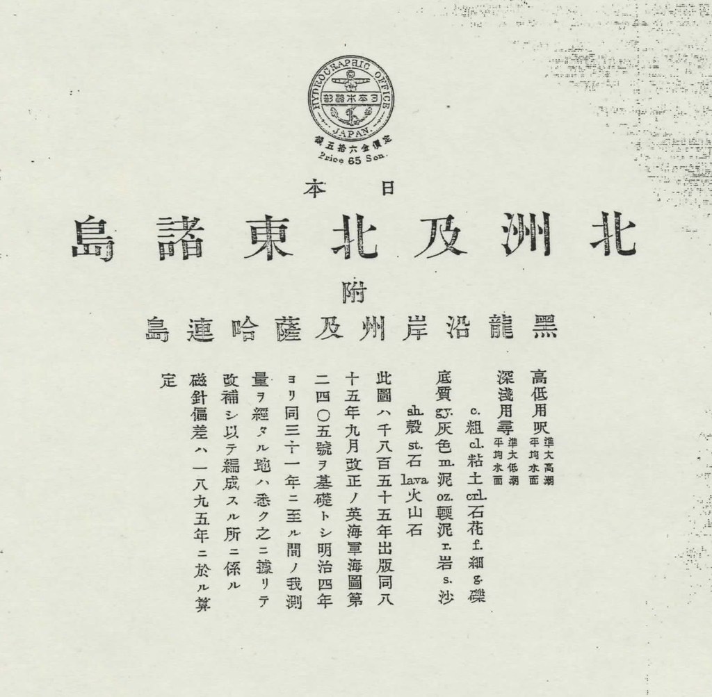
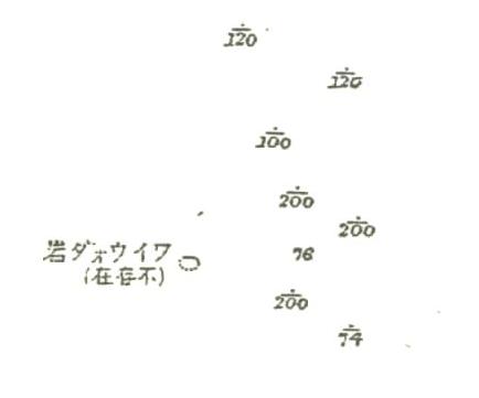
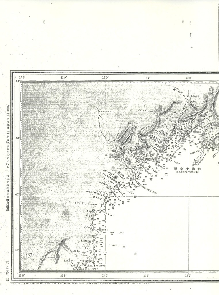
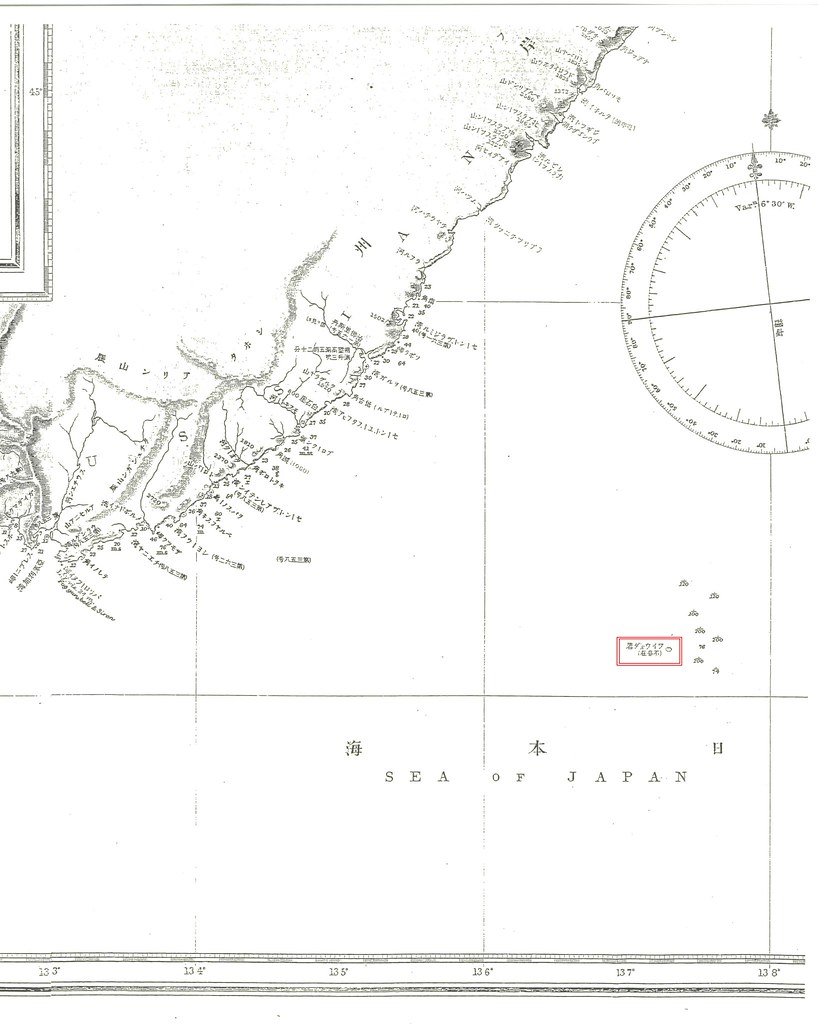
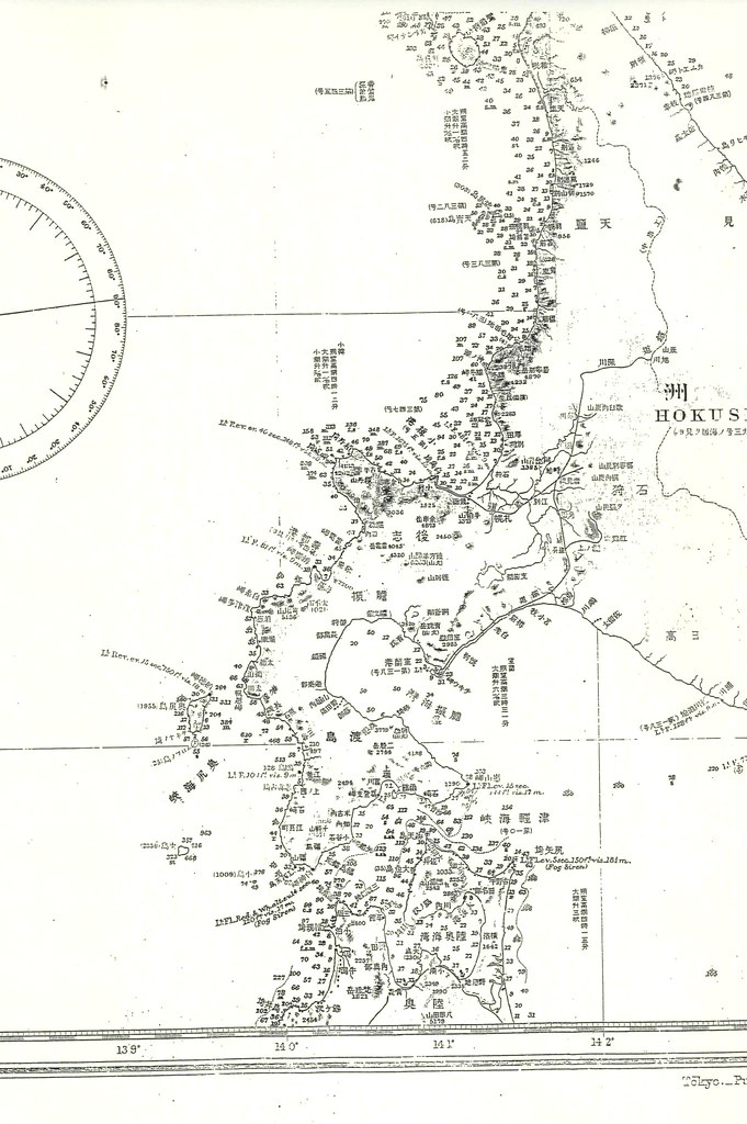
"The Sea Chart of Hokkaido and Northeastern Islands(北洲及北東諸島)" was made by Hydorographic Office of Japan(日本水路部), basing on the British Navy's seachart, in 1893 originally, just a year before the 1894 version of "Choson Seaway (朝鮮水路誌)" was published. The map plots Waywoda rock near Okushiri island of Japan's Hokkaido and it also shows the trace Japanese Navy did fathomed to survey around the area, but labelled as "non-existant" just like British "China Sea Directory" reported. The location is exactly the place 1894 "Choson Seaway" reported and it is clearly far outside of Korean territory at a glance.

Pro-Korean scholars like Prof. Hori Kazuo(1987) wrongfully claimed as follows and pro-Korean scholars have been blindlessly following his unrealistic claim even up until now.

"しかし、海図は地理的な認識を示すだけなので、海図中の島の所属については、その解説書たる水路誌を重視しなければならない。"(p105)
----------------------------------------------
"However, marine charts usually show geographical features and do not specify sovereign rights to islands in them. As for sovereign rights to islands, therefore, one has to consult a guide to sea routes, an expounder of a chart.(p105)"

"そして他方、日本海軍の『朝鮮水路誌』一八九四年版と九十九年版には、鬱陵島と並んでリアンコールト列岩が載せられている。つまり十九世紀末に、日本海軍の水路部当局が竹島=独島を朝鮮領だと認識していたことは、疑いのないところである。"(p106)
-----------------------------------------------
"Moreover, the 1894 and 1897 editions of the Chosen suiroshi (Korea's Sealanes) by the Japanese Navy show Liancourt Rocks/Tokdo,26) along with Ullungdo. There is no doubt the Japanese naval hydrographic anthorities were aware Takeshima/Tokdo belonged to Korea around the end of the 19th century.
"

First of all, waterway magazines are just "guide to sea routes" and they don't represent the "sovereign rights to islands". They are written for the safety of the voyages as well as seachart. In fact, Liancourt Rocks was listed along with Matsushima(Ulleungdo) and Waywoda rock as "dangerous rocks in the Sea of Japan(左ニ記載スルモノヲ除ク外日本海内絶エテ暗岩危礁ナシ)" for the safe voyages in 1894 "Choson Seaway". And Waywoda Rock was reported as situated in lat. 42°16′N., long.137°18′E. , way up north from Korean territorial limit in the first place. Pro-Korean always wrongfully refer to this book as one of the evidences Japanese considered Takeshima as Korean territory only because it was listed in the section "East Coast of Choson" of "Choson Seaway.", ignoring Waywoda rock, which is clearly outside of Korean territory, was also listed in the same section.

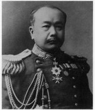
Moreover, the preface of this waterway magazine clearly depicts eastern limit of Korean territory is 130º 35' E.longitude, under the name of the Kimotsuki Kaneyuki (肝付兼行),a director of Hydrography Department. From this fact, we can see that Kimotsuki clearly recognized that Takeshima/Dokdo was outside of Korean territory when Nakai met him in 1904.

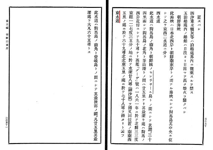
Lastly, Eastern Strait(東水道) of Choson Strait, between Tsushima and Iki(壱岐) of Nagasaki, Japan was also listed in the previous chapter(Chapter 3). You cannot claim that the strait between Tsushima and Iki also belong to Korea only because it is listed in the "Choson Seaway". It also proves that Liancourt Rocks in this waterway magazines were not for territorial issue, but only for the safety of voyages.

It is funny to see that the Prof. Hori's old unreliable thesis based on out-of-date resources, written more than 20 years ago, is still keep followed by Korean scholars and made them look stupid worldwidely.

1893 北洲及北東諸島_11893 北洲及北東諸島_221893 北洲及北東諸島_41893 北洲及北東諸島_5

29.12.08

2008 - Dec. 28 - S. Korea protests Japan's territorial claim to Dokdo

SEOUL, Dec. 28 (Yonhap) -- South Korea on Sunday strongly protested Japan's stepped-up move to claim Dokdo, the easternmost South Korean islets in the body of water between the two countries.

A day earlier, Japan's Yomiuri Shimbun newspaper reported that the Japanese Foreign Ministry has published a 14-page booklet detailing its claim to the islets in seven more languages -- Arabic, Arabic, Chinese, French, German, Portuguese, Russian and Spanish -- in addition to English, Korean and Japanese. (Yonhap News)
----------------------------------------
Seoul protests Tokyo’s Dokdo claims--December 30, 2008

Seoul on Sunday repeated its years-long routine of filing yet another complaint to Tokyo against Japan’s claims to the Korea-controlled islets of Dokdo.
(---------)
According to the newspaper, the ministry has distributed more than 23,500 such brochures in Japanese, Korean and English at home and abroad.

But since early December, it started making the booklets in a total of 10 languages, adding Chinese, French, Arabic, German, Portuguese, Russian and Spanish, and distributing several thousand to Japanese foreign embassies. The Japanese Foreign Ministry also updated its official Web site so to include its territorial claims.

“We again made a strong demand that the materials be removed,” Korea’s Foreign Ministry said in a statement. (Joong Ang Daily)(cache)
Korean government officially admitted that Takeshima/Dokdo is disputed island, again .

Here is the pamphlet "10 Issues of Takeshima" in 10 languages. Japanese Ministry of Foreign Affairs do their job stealthly, somehow. Nobody had noticed until Yomiuri Shimbun reported. Then Korean media always advertise the news worldwide.

English [PDF] / Japanese [PDF] / Korean [PDF] / Arabic [PDF] / Chinese [PDF] / French [PDF] / German [PDF] / Portuguese [PDF] / Russian [PDF] / Spanish [PDF]

25.12.08

Review of Korean Documentary, "Sorry, Dokdo"

The following is an excerpt from a December 25 "Korea Herald" review of the Korean documentary, "Sorry Dokdo."

Dokdo, a group of islets in the East Sea, is a deeply emotional issue for Koreans. Whenever Japan claims territorial rights to Dokdo, the Korean press, civic groups and individuals are quick to express their anger. But a territorial dispute cannot be resolved with emotions only, an idea that is painfully explored by "Sorry, Dokdo," the first Korean film dedicated to Dokdo.

Directed by Choi Hyun-muk, the documentary shows how meticulously Japan has been taking steps to claim its sovereignty over what it calls Takeshima. Choi makes a claim that Japanese authorities and scholars have been producing a growing body of official documents and scholarly research while Korean counterparts neglect amassing academic evidence.
The problem is not that Korean authorities and scholars have been neglecting their duty to collect evidence; the problem is that there is no evidence for them to collect since Takeshima (Dokdo) was never part of Korean territory before it was forcefully occupied by Koreans in the early 1950s.

Except for returning Takeshima to Japan, the next best thing the Korean government can do is to be quiet about the issue, so as not to draw attention to the fact that the islets were stolen from Japan.

24.12.08

"New high school draft curriculum avoids islets row"

The following is an excerpt from a December 23, 2008 article in The Japan Times entitled "New high school draft curriculum avoids islets row":

A draft revision of the education ministry's curriculum guidelines for high schools released Monday does not specifically mention the Takeshima islets disputed with South Korea.

This follows the tussle between Tokyo and Seoul earlier this year over a reference to the territory in a similar document for junior high schools.

The draft covering high school geography classes remains unchanged from the current document in terms of guiding teachers to "touch on Japan's territorial issues" but without giving specific examples of such problems.
Meanwhile, Korean geography books continue to claim very clearly that "Dokdo" (Takeshima) is Korean territory.

Also, here is another excerpt from the article that confuses me:

The draft seeks provisions that enable students to review the contents of compulsory education, which cover elementary and junior high school years, in light of the diversification among students who go on to attend high school, owing to a 98 percent advancement rate.

The ministry gave up on an earlier plan to make Japanese history compulsory in the geography and history section, while keeping world history as a compulsory class.
World History will be compulsory, but not Japanese History? If true, then doesn't Japan's Education Ministry have its priorities backwards? Can someone please explain to me what is going on in Japanese education?

By the way, Korea is also being relatively quiet about the Dokdo issue, but that will almost certainly change sometime around Takeshima Day.

21.12.08

1853-1922 - Kimotsuki Kaneyuki (肝付兼行)

Kimotsuki Kaneyuki, a director of Hydrography Department, and a mayor of Osaka, was born in Kagoshima(鹿児島) in1853. He is a nephew of Komatsu Tatewaki Kiyokado (小松 清廉(帯刀) ). The lieutenant of naval forces(海軍中尉), is known as the first Japanese who observed latitude by the Talcott Method, and obtained the value of 35 degrees 39 minutes 17 seconds 492 of north latitude in the Tokyo Azabu naval forces marine meteorological observatory in 1876. This was the first measurement of numerical value in the Japanese latitude and longitude datum point. He was the person who measures the latitude value of the Japanese latitude and longitude datum point, and executes a Japanese original domestic longitude telegraphic communication measurement for the first time.

Kimotsuki's previous name was Eda(江田), then Ohtomo(大伴), and his childfood name was Sentaro(船太郎). He served Hokkaido Development Commissioner(北海道開拓使) from 1869, surveyeing the land, then worked for the waterway division in 1872. He observed 19 pairs of the stars 109 times by the Talcott method with Dabittoson meridian transit instrument based on the Washington star table, and Astronomical latitude was decided by his effort in 1876. This is the "Kimotsuki Point" of naval forces marine meteorological observatory in Azabudai, Minato, Tokyo and the latitude values of the Japanese latitude and longitude starting point were made by shifting this value to the transit circle (子午環). Though he planned for the passing difference observation between Hokkaido and Tokyo in 1876, he had to change the plan to the measurement between Aomori of Tokyo due to the breakdown of the bottom of the sea electric wire. This is the first longitude telegraphic communication measurement in Japan.

Kimotsuki started from a clerical work at the marine meteorological observatory, then served as a subleader of the measurement section, later became the chief of land surveyrance section in 1883. He became the second and the forth director of the Hydrography Department and served for 16 years as a director, contributing the development of the waterway business enormously. After he had retired from the service, he became the member of the House of Peers(貴族院) in 1911 and the mayor of Osaka city in 1913.

The waterway division started by the Yanagi Narayoshi(柳楢悦), a father of Yanagi Muneyoshi (柳宗悦) who had devoted to the folk arts from Korean Lee Choson Dynasty, as a waterway inspector, one commander, and two majors or less in 1871. They executed the Hokkaido coast measurement at first in cooperation with the British warship Sylvia, and gradually built a system to be able to conduct waterway measurements by themselves. The first chart "Kamaishi(釜石)" was completed in September, 1872, and a real waterway measurement had thus begun.

The division became independently to naval forces Hydrography Department in 1886, and afterwards, it became big organization of 105 people of the number of staff, and the Yanagi became the founder director of Hydrography Department and the Kimotsuki, a measurement section chief in the waterway divisionin 1887.

In 1880, Navy sent warship Amagi and found "Takeshima" which was questioned for its sovereignty by Japanese was Jukdo(Boussole Rock) and "Matsushima" was Ulleungdo. Today's Takeshima/Liancourt Rocks hadnever been a matter of territorial concern between two countries before 1906. When Nakai Yozaburo, a businessman from Oki came to him and sought an advise from him in 1904, he, as a director of the Hydrography Department who published 1894 "Choson Waterway Magazine" which clearly states that Korean eastern limit is 130°35′, said it should be Japan's. Since Kimotsuki was a specialist of surveyrance, it was natural for him to correct Nakai Yozaburo's misunderstandings that Liancourt Rocks "belonged" to Korea from "seacharts", which has nothing to do with territory claim and advise him that it should be Japanese territory since the sovereignty of Liancourt Rocks was indeterminate and it is nearer to Japanese main island than Korean peninsula.

同島の所属は確乎たる徴証なく、ことに日韓両国よりの距離を測定すれば、日本の方十浬の近距離にあり(出雲国多古鼻より百〇八浬、朝鮮国リッドネル岬より百十八浬)加ふるに、朝鮮人にして従来同島経営に関する形迹なきに反し、本邦人にして既に同島経営に従事せるものある以上は、当然日本領土に編入すべきものなり(『竹島経営者中井養三郎氏立志伝』 (奥原碧雲, 1906) )
--------------------------------
There is no concrete evidence of sovereignty of the island. And especially measuring the distance from both Japan and Korea, it is closer to Japan by 10 nautical miles. (It is 108 seamiles from Takohana, Izumo country and 118 nautical miles from Lidnell cape of Korean peninsula. ) and as far as there are Japanese who are already engaging in managing the island while there is no trace of Koreans who managed the island, it is natural to incorporate it to Japan. ("The Manager of Takeshima; The Success Story of Mr. Nakai Yozaburo" by Okuhara Hekiun, 1906)

As we have seen on this blog, this is exactly the situation Liancourt Rocks was under in 1904. At the time in 1904, all the books and maps published in Japan, western countries and even Korea herself we had checked so far clearly described Takeshima/liancourt Rocks was outside of Korean territory. Many Japanese and western maps depicted Liancourt Rocks as Japanese territory, some depicted it as tella nullis, but none as Korean. Moreover, there is no single evidence of any display of functions of state and governmental authority by Korea until 1950s, when Korean president Lee started its military expansionism and illegally occupied Takeshima right after they noticed U.S. denied Korean sovereignty over the island in San Francisco Peace Treaty. Those facts firmly support Kimotsuki's fair and logical advice to Nakai in 1904. It is absurd to even hint that Kimotsuki had some kind of military pourpose or expansionism without any evidence, like pro-Korean professors Prof. Hori Kazuo, Prof. Emeritus Naito have been wrongfully insisting.

In spite of Korea's desperate pursuit for finding similarity between the 1905 Takeshima Incorporation by Japan and 1910 Japanese annexation of Korea, there is absolutely no evidence that those two incidents shared any direct connection. Incorporation of Takeshima into Shimane was nothing like a "stepstone" for the annexation, but simply a peaceful process which followed the international law.

Japanese government incorporated Takeshima, reconfirming/replacing its historic title with modern title in 1905 and Korean Imperial government officially acquiesced the Japan's sovereignty over Takeshima/Dokdo by not expressing protest against Japan in 1906.

References:

Korean Eastern limits described in various books world wide exclude Takeshima/Dokdo from Korean Territory

The Territorial Recognitions which Western Maps of Japan Show for Takeshima/Liancour Rocks between 1880-1905 : Ver.1

1880 - Japanese Warship "Amagi" (軍艦天城) Surveys Ulleungdo and finds "Takeshima" is Jukdo.

1881 - Kitazawa Masanari(北澤正誠), a official of MOFA concluded that "Takeshima" is Jukdo in "A Study of Takeshima (Takeshima Kosho 竹島考証) "

1900 - The Times Map (China and Japan, Printing House, London)It shows Ulleungdo = Korean , Liancourt Rocks = Japanese

1906- Feb 20 & April 17 - "Official Documents of the Ministry of Internal Affairs Vol.1" - Korean government protested about land transaction in 竹邊浦

18.12.08

Integrity finally wins one

The following is an excerpt from a December 18 Joogang Daily article entitled, "100,000 won bill can wait."
At the time, Finance Ministry officials cited the bill’s design as a key issue behind the postponement. On the bill’s front, Kim Gu, a Korean independence fighter under Japan’s colonial rule in the early 1900s, was to be featured. The back was supposed to depict the “Daedongyeojido” - a wood-engraved map of the Korean Peninsula created by Kim Jeong-ho, a geographer and cartographer during the Joseon Dynasty. But controversy emerged after it was revealed that Kim’s engraving did not include Dokdo, a controversial group of Korean islets in the East Sea, which Japan claims as its own territory. Public sentiment would have the BOK add Dokdo, but doing so would compromise the integrity of the original work.
Finally, "integrity" wins out over "public sentiment," for now.

HERE is another article on the topic from the AFP.

11.12.08

1950 The Daily Telegraph Map of Korea

This map of Korea was specially drawn for the Daily Telegraph by Geographia Ltd, 167 Fleet Street, London in circa 1950.

One can clearly see an island labelled as "Ullung" (Ulleungdo) in the Sea of Japan, but there are no Liancourt Rocks. It is natural because Korea's eastern limit was believed to be Ulleungdo and it was believed that Liancourt Rocks were out of Korean territory in those days.

But please think of the Korean claim demanding Tsushima, Dokdo (Liancourt Rocks) and Parangdo - it was made in July 1951 - just around the time this map was made.
..........

http://dokdo-or-takeshima.blogspot.com/2008/08/1951-coversation-of-yu-chan-yang-with.html


Obviously Korea's claim was received by the world as outrageous. So USA reproved Rhee Syngman, the then president of South Korea, for his unlawfullness but he didn't listen to the advice.


Adedendum: Broughton Bay was labelled as "East Korea Bay".

10.12.08

1794 - June 3 - "正祖実録 正祖18年6月3日条" Gajido(可支島) was described as a place on or near Ulleungdo, not Takeshima/Dokdo.

In the 1953 edition of Seoul Newspaper, famous Korean journalist, poet and historian Choi Nam-seon(崔南善), who advised Korean government to claim not only Takeshika/Dokdo, but also Parando addition to Tsushima as their territory in early 1950s, wrote that Gajido(可支島), which means “Seal Island” in 1794 Korean official document, was also another name of Dokdo, along with “Usando” (于山島) , “Sambongdo” (三峰島) , “Jasando” (子山島) and “Seokdo” (石島, Korean Imperial Edict 41)" . He reasoned that there were no islets other than Takeshima/Dokdo which was uninhabited, but merely sealions were living on. Koreans today still blindlessly follow his immature idea almost 60 years ago. However, sea lions used to live on Ulleungdo which was uninhabited island until 1882 and the documents mentioning “Gajido” described it as a place on or near Ulleungdo, actually.

What is 可支島?
The report("正祖実録 正祖18年6月3日条") said that on the 26th, the Ulleungdo inspection party, who had proceeded from southwest to north on the eastern coast of Ulleungdo, changed directions, which can mean they reversed course, and headed to Gajido (轉向可支島). This suggests that Gajido (可支島) was somewhere back in the direction that had come, which means they headed back southwest, not 92km southeast where Takeshima/Dokdo locates. According to Mr. Choi, this Gajido was today's Takeshima/Dokdo, since sealions, which were shot by riflemen there, were seen on Takeshima/Dokdo, not around Ullgundo in 1950s and the island was uninhabitable.

正祖実録 正祖18年6月3日条

江原道觀察使沈晋賢狀啓言:
...二十六日轉向 可支島 , 四五箇可支魚, 驚駭躍出, 形若水牛。 砲手齊放, 捉得二首, 而 丘尾津 山形, 最爲奇異, 入谷數里, 則昔日人家遺址, 宛然尙存。
----------------------------------------------
Gangwondo Governor Sim jin-hyeon reported to the king.
“...We slept there and on the 26th, we changed direction (reversed course) and went to Gajido (可支島), where we surprised four or five sea lions that dashed out. They looked like water cows. Our riflemen all fired at once and got two of them. The geographical features of the beach landing (丘尾津) was the strangest thing. We went about ten ri into the valley, where we found the remains of what were clearly ancient dwellings. On both sides, the hills and ravines were so deep that they were difficult to climb up."

However, there is little or no basis for such a claim since the report mentioned no coordinates for Gajido (可支島), no bearing, distance, or description. Besides, it says they found the remains of human dwelling on a same day they saw sealions. There were no such remains on Takeshima at all. And there are no other references to the island in Korean historical documents. Korean base their claim solely on the fact that sea lions lived on both Gajido (Seal Island : 可支島) and on “Dokdo” (Liancourt Rocks). The problem with that logic, however, is that it ignores the fact that sea lions or seals also lived on Ulleungdo.

Actually, there are many documents which backs up this fact. For example, Japanese Ohya clan and Murakawa clan in 1600s frequently voyaged to both Ulldungdo and Takeshima/Dokdo and they were hunting sealions on both. (ex. "竹嶋之書附 ","小谷伊兵衛ニ所持被成候竹嶋之絵図之写:享保9年(1724)") Korean old maps also frequently list the skins of sealions(可支魚皮) as a products of Ulleungdo(ex. "Haedong Jido" (海東地圖) ). There are more as listed below.

Many Korean documents prove that there were Sealions living on Ulleungdo.

Dongguk Munheon Bigo(東國文獻備考 (1770)) stated that there were cows looking creatures lying on the beach of Ulleungdo("海中有大獣牛形赤眸無角群 臥海岸見人獨行害之遇人多走入水名可之").

1786 Inspection of Ulleungdo went to Gaji Beach (可支仇味) and found two caves of which some sea lions that dashed out.

We advanced to Gaji-gumi (可支仇味- Sea Lion Cove), where we found two caves in the side of the mountain.It was difficult to calculate their depth. We surprised some sea lions
that dashed out (of the caves), but before they could get into the water, all our riflemen fired at once and got two of them.

--------------------------

前進可支仇味則山腰有兩石窟其深難測可支魚驚出投水之際砲手齊放捉得二首

1827 Inspection of Ulleungdo also said there were many sealions on Ulleungdo.

They went to Sea Lion Cave
(可支魚窟), where they surprised seven or eight sea lions. They shot and clubbed them and got two of them before they could jump into the sea.

------------------------
又到可支魚窟則可支魚七八首驚人入海之際砲搏捉得二首

1831 Inspection of Ulleungdo also said that they saw almost 110 sealions on Ulleungdo.
They then headed to Hyeonseok-gumi (玄石龜尾 - "Black Rock Cove"), where they saw a herd of about 110 sea lions mooing like cows. They got two of them with guns and clubs.
------------------------
仍向玄石龜尾則可支魚百十爲群吼哮如牛或砲或棒捉得二首
1882 Korean official map of Ulleungdo depicts a cave on the west side of the island called Gaji-gul (可支窟), which means “Seal Cave.”

1899 September edition of Korea’s Hwangseong Newpaper printed an article that talked about "Gaji(可支 = Sealions)" on Ulleungdo.

In the past , there were water animals that looked like cows without horns that were called “gaji” .

-------------------------------

古에牛形無角한 水獸가 有하니 名曰可之오

As many Korean own documents and maps above clearly show, it is no doubt that Gajido was a place on or near Ulleungdo, not Takeshima/Dokdo. Korean must stop illogical silly claim that Gajido was today's Takeshima/Dokdo right away.

Reference;

1794 - June 3 - Han Chang-guk (韓昌國) Inspects Ulleungdo (日省録)

Lies, Half-truths, and Dokdo Video, Part 2

Lies, Half-truths, and Dokdo Video, Part 3

Lies, Half-truths, and Dokdo Video, Part 4

Lies, Half-truths, and Dokdo Video, Part 4 Supplement

Lies, Half-truths, and Dokdo Video, Maps 2

Lies, Half-truths, and Dokdo Video, Maps 2 Supplement

Sea Lions on Ulleungdo