竹島問題の歴史

25.7.09

1754 - "The Field Chart of Japan, The Atlas of Japan (日本輿地図 日本分野図)" by Mori Kohan( 森幸安) described Takeshima(Ulleungdo) as Japan's territory

"The Field Chart of Japan (日本分野図)" by Mori Kohan( 森幸安) described Takeshima(Ulleungdo) as Japan's territory.

Left : "The Field Chart of Japan (日本分野図)" from the site of National Archives of Japan

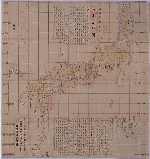
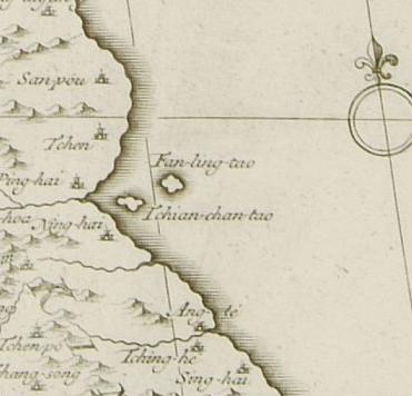
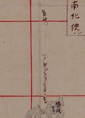
As we can see, "The Field Chart of Japan (日本分野図)" by Mori Kohan( 森幸安) clearly described Takeshima(Ulleungdo) as Japan's territory by drawing the sea route line from Oki to Ulleungdo. Nagakubo Sekisui is considered to have referred this map the most in the creating process of "Revised Complete Map of Japanese Lands and Roads", which Korean claim Nagakubo excluded Takeshima from Japan's territory, etc. In other word, against Korea's claim, this "The Field Chart of Japan (日本分野図)" by Mori Kohan( 森幸安) reinforces the Japan's claim that Nagakubo clearly recognized Takeshima and Matsushima as Japanese territory in 1779.

Right : Closeup of "The Field Chart of Japan (日本分野図)" from the site of National Archives of Japan

Nagakubo Sekisui(長久保赤水) depicted Takeshima as Japan's territory on his map of Japan.

A group of island that are currently called Takeshima were once known as "Matsushima," and the island that is now known as Utsuryo (pronounced Ulleung in Korean) used to be known as "Takeshima" or "Isotakeshima." Although there has been a period of temporary confusion concerning the names of Takeshima and Utsuryo Island due to an error in the charting of Utsuryo Island by European explorers and others, it is obvious from a variety of written documents that Japan has long recognized the existence of "Takeshima" and "Matsushima." For example, on many maps, including "Kaisei Nippon Yochi Rotei Zenzu (Revised Complete Map of Japanese Lands and Roads(日本輿地路程全図): first published in 1779)" by Sekisui Nagakubo, which is the most prominent published cartographic projection of Japan, the locations of Utsuryo Island and Takeshima are accurately recorded at their current position between the Korean Peninsula and the Oki Islands. (MOFA, 2008)

Korean claims that the "Onshu-shicho-goki(隠州視聴合記)" and "the Complete Map of Japanese Lands and Roads", both of which Japan used as the basis to prove that Takeshima (Dokdo) was Japanese territory, instead are the basis to prove that Dokdo is Korean territory. The interpretation of the sentence “Viewing Koryo is just the same as viewing Onshu (Oki island) from Unshu (Izumo) [見高麗猶雲州望隠州]” makes it clear, however, to which of Japan or Korea the place where one could view Koryo belonged. Nagakubo Sekisui made that notation next to Ulleungdo when quoting from the Onshu-shicho-goki because he believed that Ulleungdo was Japanese territory--he wasn’t reconfirming that Dokdo was Korean territory.


Indeed, Saito Hosen, the author of Onshu-shicho-goki, also wrote in the book the fact that the Oya family from Yonago of the Tottori domain frequently visited Ulleungdo. He had no doubt that Ulleungdo was Japanese territory. And when one of the Oya family’s ships drifted ashore in Korea in 1666, one year before the publication of Onshu-shicho-gouki, the Korean government graciously returned it. The Edo Shogunate grasped the meaning of that event and also recognized that Ulleungdo was Japanese territory. Even in 1695, when Edo Shogunate banned Ohya and Murakawa clan the voyage to Ulleungdo, both government didn't even hinted Usando in the process of negotiacion, not to mention of Matushima, today's Takeshima/Liancourt Rocks, which suggests that Joseon didn't even know the existence of the tiny island 92km far from Ulleungdo. Ulleungdo had been the easternmost of Joseon territory, and none of Korean historical documents suggest Ulleungdo nor Usanguk, the old name of coutry of Ulleungdo, includes Takeshima/Dokdo. As we have seen, there is no evidence that Koreans ever traveled to Liancourt Rocks (Dokdo/Takeshima) before Japanese fishing boats started taking them there in the early 1900s, and the islets do not appear on any of Korea's old maps by any name.


Other concrete evidences that Nagakubo Sekisui considered Takeshima(Ulleungdo) and Matsushima as Japanese territory, most likely, the country of Oki.
  1. The additional remark next to Ulleungdo, "見高麗猶雲州望隠州( From there(Ulleungdo) you can view Korea, it is just like you view Onshu (Oki island) from Unshu (east of Shimane prefecture, mainland of Japan)", on his map was cited from the " Onshu Shicho Goki (隠州視聴合記)" by Saito Hosen, which states Ulleungdo was the westmost of Japanese territory.
  2. He coloured both islands from the later edition as Japanese territory.
  3. In the first edition, not only two islands, but also other important Japanese islands like Gogohshima(御号島 : today's Okinoshima(沖ノ島), Kuchinoerabu(口永良部島)、Ezo(蝦夷地 : Hokkaido) were also uncoloured. It is obvious that those Japanese islands uncoloured were not considered to be outside of Japanese territory, but only described to be distant islands of Japan from the mainland.
  4. Nagakubo’s other map ("Map of Asia and Small Orient(亜細亜小東洋圖, 1835)") clearly shows Takeshima and Matsushima as Japanese territory.
  5. Nagakubo was in charge of compiling the geographical volume of the "Great Chronicles of Japan"(大日本史 or Dai-Nihonshi). The geographical documents were drafted by him. Under the article of 4 of district of Oki country, it says that "in addition, there are Matsushima(today's Takeshima/Liancourt Rocks) and Takeshima(Ulleundo) and those island belong to Oki.
Mori Kohan (森 幸安 : 1701(14th year of Genroku) - ?  )
Mori Kohan was born in Kyoto and studied the historical evidence for the map in the middle of Edo period. He collected or copied the maps of Japan and the world in Kyoto and Osaka from 1748 to 1763, counting almost 300 of them, and information related to the map was written down in detail on a margin by the Chinese writing . It is said that he combined those maps to produce "The Atlas of Japan (日本輿地図)". "The Field Chart of Japan (日本分野図)" of "The Atlas of Japan" described the parallel and the meridian for the first time as Japanese map and even latitude is recorded on the parallel line. Mori noted that he recorded the latitued to record the climate of each latitude (Japan is a warm coutny with the four seasons). Takeshima is also described as Japanese territory with sea route from Oki.

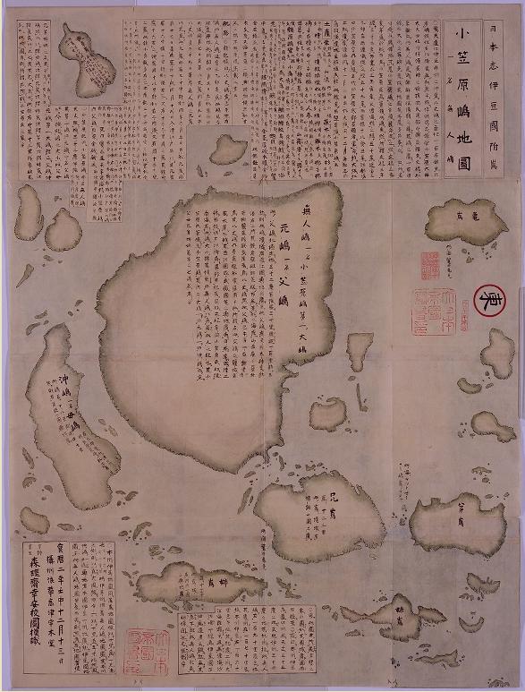
(Right : "The Map of Ogasawara islands (1752)" from "The Atlas of Japan" by Mori Kohan. It shows that Ogasawara Islands(Bonin Islands : 無人島) were well-recognized by Japanese as its territory way before American came around in 1800s.)

References :
Shimane Prefecture (Eng. Jap. & Kor.)
Japanese Ministry of Foreign Affairs (Eng.)

The 19th column “Seeking Truth Based Solely on Facts(実事求是)”

1696 - Ordinance Prohibiting Voyages to Takeshima (幕府 渡航禁制令)

1835 - "Map of Asia and Small Orient(亜細亜小東洋圖)" shows Takeshima/Dokdo as Japanese territory

1667 - Onshu Shicho Goki (隠州視聴合記)
1667 - "Onshu Shicho Goki(隠州視聴合記)" - The different translations

14.7.09

2007 - "The analysis of the western maps" by Funasugi Rikinobu

This is from the Final report by Takeshima Research Center, 2007 (竹島研究会最終報告書 2007)

"Takeshima in Illustrative Maps and Maps Vol.II " (絵図・地図からみる竹島(II)) 


2. The analysis of western made maps( 2. 西欧製地図の分析)

by Associate Professor Funasugi Rikinobu (Shimane University)
(舩杉力修 島根大学法文学部・歴史地理学)


2. The analysis of the western maps
(Overview)

Western maps have been the object of the study in Takeshima-issue. According to Kawashima(1966), the map of Korea in "the collection of Chinese maps "by D'Anville (1779) have the two islands, "Tchiang-chan-tao"(west side) and " Fanling-tao"(East side) , the former being Usando the latter being Ullenungo in Chinese pronunciation, but these were just a copy of Korean old document. without investigation. This map had a great influence over European maps thereafter.

In 1787, when Dagelet found Ulleungdo, it was named after him, and the name "Dagelet" started to appear on the maps. In 1789 Argonaut found the Ulleungdo, named the island after it, but he failed to measure it exactly and spotted it on the map in the northwest of the real island; consequently , two islands for the one island, Ulleungdo, began to appear on the western maps.Arter that, Siebold compared the Japanese maps with European maps, and he mistakenly identified "Argonaut" with "Takeshima"(Ulleungdo) and "Dagelet" with "Matsuhima"(Takeshima/Dokdo);as a result, the map thereafter had been wrongly drawn under this misperception .

In 1849 French ship found Takeshima/Dokdo and named it Liancourt after its name, now the maps have three islands, "Argoaut"("takeshima"), "Daglet"("Matsuhima"), and Linocourt. But later it was found out that there was no island corresponding to "Argonot", so in 1900's the maps began to list only two islands, Daglet and Liancourt. The confusions were due to Siebold's misidentification. Korea claims that even western maps prove Dokdo was Korean territory just because D'ANVIL map has two islands, "Tchiang-chan-tao" and "Fanling-tao".

This paper will examine as many western maps as possible and investigate how these islands referred above appeared in the western maps. However, since the number of western maps is enormous and since it is difficult to systematically check them all, I took the following measures.

I have examined "the collection of classic maps of Japan" and "the compilation of old Japanese maps" among Akiyama Takeshiro's collection, and I also used the Internet western old maps on the website of Kansai University. In total, I examined 74 Japanese and Asian maps by European people which had Oki islands, Ulleungdo, and Taekshima/Dokdo. The times of the maps examined is from the middle of 16 century when Oki islands appeared for the first time in the western maps to the late 19 century when the boarder is not drawn as clearly as now. I summed up the result in figure 2 on another sheet.

① Until the middle of 18century
Only Oki islands were spotted on the western maps. That means westerns had no cognition of the western part of Japan Sea other than Oki islands. Oki islands appeared on almost all the western maps after the middle of 18 century. Some of the maps of Japan were made based on Japanese maps such as "map of Japan on a folding screen" (日本図屏風), which was probably made in the late 16 century in Joutoku temple of Fukui Prefecture(福井県), "South barbarian map on a folding screen(南蛮屏風), which belonged to the same family tree to the map just mentioned , "new anthology of maps about great Japan "(新撰大日本図鑑)(1678), "the map of Japan's mountains and sea(日本海山潮陸図)(1691)by Ishikawa Tomonobu (石川流宣). "Map of Japan on a folding screen" and "Southern Barbarian map on a folding screen" has Ulleungdo as Isotake between Oki and Goryeo but western maps based on them didn't list it for some reason. As a side, "new anthology of maps of great Japan" and "the map of Japan's mountains and sea does not have "Takeshima"(Ulleungdo) and "Matsuhima"(Takeshima/Dokdo) on them.

② From the middle of 18 century to the early 19 century
From the middle of 18 century, Tchiang-chan-tao(Usan) and Fanling-tao(Ulleungdo) began to appear on western maps. It might be that the map was made based on 1530 Korean map " "Map of the Eight Provinces (八道總圖 - 팔도총도)" in the middle of 16 century because the islands were spotted on the east of Korea and Usan is in the west, Ulleungdo in the east. As Kawakami points out, it seems these maps were under the influence of D'Anville.

D'Anville, Jean Baptiste Bourguignon(1697~1782)
was a French geographer and published "new map of China" in 1737 (Left : from the site of Hokkaido University Library) based on the1735 map made by missionaries who stayed in China. Thereafter, this 1737 map had been the standard map of China, This map included the map of Korea, which had Tchiang-chan-tao、Fanling-tafor on it. (The national museum of Korea printed it in its leaflet.) Almost all the maps with these two islands locate Usan in the west, Ulleungdo in the east. "The map oft Japan" in 1750 located them similarly. It follows that Usan is not Takeshima/Dokdo.

Besides, this map is not a territorial map: it was just made based on "Map of the Eight Provinces" (1530) and Japanese maps of the middle of Edo era, so it had nothing to do with territorial boundary.

③ The early 19 century
In the early 19 century, maps with "Argonaut" and " Dagelet" came to existence besides the maps with "Tchiang-chan-tao" in the west and " Fanling-tao " in the east. These are all the name for Ulleungdo. In other words, four islands were drawn on the western maps in this period. "Argonaut" and "Dagelet" was "discovered " due to the developed technology of measurement at the time. "Dagelet" was discovered by French in 1787, "Argonaut" in 1789 by Britain. Since these islands were not colored on the map, they were recognized as no man's island. In this period, maps were made based both on traditional Korean maps and on western technology of measurements.

④From the middle of 19 century to the late 19 century
In the middle of 19 century, "Tchiang-chan-tao" and "Fanling-tao" gradually began to disappear from the maps. In some maps like the British map of "Japan and Korea" , 68th map on another sheet, only "Tchiang-chan-tao" disappeared and Fanling-tao、Argonaut、Dagelet remained. Incidenally, the maps were colored and Fanling-tao and Argonaut were colored yellow and Dagelet colorless, indicating tha Fanling-tao and Argonaut belongs to Korea and Dagelet belongs to no country. But since the maps were confused as to the existence and location of the islands, it has little significance. (By 1865 Argonaut finally disappeared from the map. * )

In 1840, Siebold mistakenly identified Argonaut with Takeshima and Dagelet with Matsuhima after he compared Japanese maps with western maps. Thereafter, however, his notation became a standard for western maps.
Takeshima/Dokdo notated as Linacourt began to appear on the western maps about this time. It was named after the French whaling ship Liancourt which discovered the island. (British map notated it as Hornet. I , though) Finally the maps began to depict Dagelet and Liancourt island accurately.

In the German map of Korean and Japan in 1870, (right / 72th map on another sheet), the present Ulleugdo was notated as Matsushima(Dagelet.) and in the south-east of it , you can see Liancourt.R(Hornet.I), Takeshima/Dokdo. Judging from longitude and latitude、they are accurately depicted. Interestingly note the boader line was drawn in the west of Matsuhima (Ulleungdo). The map showed the cognition that . the west of Ulleungdo was the boundary between Korea and Japan.

Incidentally Korean newspaper, Chosun Ilbo on 15 January 2004, reported that they discovered the French map in 1894 which indicated that Dokdo belongs to Korea. The map was in French daily newspaper Le Petit Journal in 1894 and the title was "the map of Korea, Japan, East China." They say that the map has the boundary between Korea and Japan, and Ulleungdo and Dokdo were on the map, Dokdo noted as I.Ouen-Sa (Usando).

The Prof. of Hanyang University, Shin yon-ha said that it was the first time that the map with territorial boarderline was publicized and he concluded that Dokdo was internationally considered as Korean territory. However, examining the map closely, you'll find no Ulleungdo on the map which he claims to be drawn as Ulleungdo. Besides, I.Ouen-Sa(Usando), which he claims to be Dokdo, is Ulleungdo judging from longitude and latitude.:It is not Dokdo. And the present Takeshima/Doko is not depicted. This map is not the type based on the developed technology of measurement and belongs to the classic type of the map.

The wrong conclusion seems to be due to the error in the elementary method he employed: there is strong basis that Usando is Dokdo, the study is not based on the history of western maps and geography, even the longitude and latitude are not checked, which is very basic in reading maps.

In conclusion, western maps only recognized Oki Islans until 18 century. In the middle of the century Western maps were made based on 1530 Korean map "(八道総図), but since Usando was in the east, it follows that Takeshima/Dokdo was not recognized while Ulleungdo was during this period.

In the early 19 century, reflecting the advanced technology of measurement as well as traditional cognition of geography, there were several Ulleungdos on maps. In the middle of 19 century, finally some maps began to reflect the actual geography. In a nutshell, in western maps, Takeshima/Doko appeared only after the middle of 19 century after the advancement of measurement technology and before that, there was no map with Takeshima/Dokodo on it.

Hence, what was written as "Usando", as was the case with Korean maps, did not refer to the present Takeshima/Dokdo. In no western map was depicted Takeshima/Dokdo as Korean territory.

(* notes by translater : Japanese government seems not to have dropped Argonaut until 1878 when British Royale Navy dropped it from the chart in 1876 version)

(There is a list of the maps he studied in the original Japanese version.)
Translated by Ponta.

Courtesy of Web Takeshima Research Center.

Other Article by Associate Professor Funasugi from the Final report by Takeshima Research Center, 2007 (竹島研究会最終報告書 2007) and the report of the Research on Takeshima Issue by Web Takeshima Research Center, 2007 (Web 竹島問題研究所 「竹島問題に関する調査研究報告書」平成19年度) posted are as follows:

"Takeshima in the Korean official map"
1530 - (1) 「八道総図」 in 『新増東国輿地勝覧』
1711 - (2)「欝陵島図形」

1770 -
(3) 「欝陵島図 in'『朝鮮地図』
1882 - (4) 『鬱陵島外図』
1899 - (5) 『大韓全図』(1899) , 『大韓輿地図』(1900 c.a.
2007 - Supplement

"Takeshima in Japanese map (1)"
1849 - (1) 「嘉永新増 大日本国郡輿地全図」

References;
1752 - Fang-ling-tau means Ulleungdo

1894 - Carte De La Coree from "Le Petit Journal"

13.7.09

"Lesson Learned From Dokdo," by Tong Kim

Tong Kim is supposedly a research professor with the Ilmin Institute of International Relations at Korea University and an adjunct professor at Johns Hopkins University's School of Advanced International Studies (SAIS), yet, his July 12 Korea Times article, "Lessons Learned From Dokdo," seems to be more evidence that when it comes to "Dokdo," Korean professors seem more than willing to throw integrity and objectivity right out the window.

12.7.09

1798 The old chart of Dagelet

Although this is not directly related to Liancourt Rocks, I've obtained a part of old chart of Dagelet island (Ulleungdo) recently and I think many readers of this blog may be interested in it. It is a part of a British chart book which was published in 1798 , as there is a writing at the bottom of this sheet of charts that reads "Published as the Act directs Novr. 1st. 1798 by G.G.& J. Robinson Paternoster Row". This sheet of charts seems to be a copy of a French chart as it was all written in French. [Click the map to enlarge]

There is a chart of L'ile Dagelet (The Isle of Dagelet) in the sheet of charts and the French note says that "Discovered by the French frigates la Boussole and l'Astrolabe. The 27th May 1787. " with the exact location of the island. [Click the map to enlarge]
Another four charts depicted other islands - "a part of the isle of Quelpaert (Chejudo)", "the isle of Hoapinsu", "a part of the isle of Botol", and "the isle of Kumi". All of these islands were only "vue" (that means "seen"), not discovered. The dates depicted in these charts may illustrate how the French frigates navigated - they saw a part of the isle of Botol on 3rd May 1787, then the isle of Kumi on 5th May, the isle of Hoapinsu on 7th May, a part of the isle of Qeulpaert on 21st May and lastly they discovered Dagelet on 27th May.

8.7.09

1945-1953 Map of Korea and Japan (USA)


This is the "Map of Korea and Japan" which was published by Military Sea Transportation Service, Department of Navy, USA. The map of Korea was made by Geographia map Co., INC in New York. The exact year of the publication is not clear but it may have been published during the years after the WWII (1945) until 1953 when the Military Demarcation Line was drawn. This map of Korea is almost similar to the map "Large Scale Map of Korea" by the same mapmaker that I already posted here; http://dokdo-or-takeshima.blogspot.com/2009/03/late-1940s-to-early-1950s-map-of-korea.html


The map shows Ulleungdo (as ULLUNG DO) but not Liancourt Rocks. [Click the left map to enlarge]


The flip side of it is a map of Japan made by the same mapmaker, Geographia Map Co. INC. There are islands in the Sea of Japan - Matsu Shima, Liancourt Rocks and Oki Shima. [Click the left map to enlarge]
They mistakenly depicted Ulleungdo (MatsuShima, Dagelet) as a Japan's island while they drew Ullun Do (Ulleungdo) as a Korean island in the map other side. There seems to have been a confusion concerning Matsushima and Ullun Do because of turmoils after the war and wrong information from the pre-war era.


But anyway, it seems to have been a firm belief for the mapmaker (and USA Navy) that Liancourt Rocks didn't belong to Korea. The rocks had been usually depicted as Japan's territory in various western maps - at least they were drawn as being out of Korean territory because Korean eastern limit had been widely believed to be Ulleungdo.

It was Rhee Syngman who broke the international rule and took the rocks by force.

It was the beginning of the Takeshima/Dokdo dispute. The issue only happened in 1952, not in 1905 when Japan incorporated the island because in those days it was a common sense that Liancourt Rocks didn't belong to Korea.

7.7.09

1896 Maps by J.G. Bartholomew (UK)

John George Bartholomew or J.G. Bartholomew (22 March 1860 - 14 April 1920) was a Scottish cartographer and geographer. As a holder of a royal warrant, he used the title "Cartographer to the King"; for this reason he was sometimes known by the epithet "the Prince of Cartography".Bartholomew came from a celebrated line of map-makers: he was the son of John Bartholomew Junior, and the grandson of the founder of John Bartholomew and Son Ltd.

These two maps were made by J.G. Bartholomew in 1896 for the Handy Reference Atlas of The World (John Walker & Co. Ltd. UK).

The first map is "JAPAN AND KOREA". [Click the map to enlarge] As it was just after the Shimonoseki Treaty (1895), Taiwan (Formosa) is shown as Japanese territory. You may notice that the national border can be seen as broken line, which shows that Japanese territory included Taiwan (Formosa), Ryukyu (Liu Kiu) islands, Tsushima and Dagelet island (Matsu-sima). Although the map didn't show Liancourt Rocks, it is obvious that Bartholomew knew that the rocks to be Japanese territory.

Please take a look at the 2nd map: "CENTRAL JAPAN". [Click the map to enlarge] It depicted literally the central Japan, mainly Honshu (mainland) with Shikoku. Please look at the islands in the Sea of Japan. The great cartographer precisely drew Liancourt Rocks (Hornet island) in this map of Japan. It is obvious that Liancourt Rocks were generally thought to be Japan's rocks, nobody believed that they were Korean territory in those days. It was a kind of common sense until Rhee Syngman stole the rocks in 1952.

6.7.09

Mark Selden seems ignorant of Dokdo/Takeshima history


Cornell University Professor Mark Selden attended a 2-day symposium on Dokdo at the Yeongnam University Dokdo Research Center in Korea from May 13 to 14. On his way home, he apparently stopped in Tokyo where he had THIS INTERVIEW with a JPNews reporter. According to the Korean translation of the interview, Professor Selden said that Japan's sovereignty claim on "Dokdo" (Liancourt Rocks/Takeshima) was "shabby" and "based on violence and aggression."

Such comments suggest that Professor Mark Selden is either ignorant of the history of Liancourt Rocks or is pretending ignorance, which is disturbing since he is a Senior Research Associate in the East Asia Program at Cornell University and a Coordinator of The Asia-Pacific Journal: Japan Focus.

The following is my translation of Professor Selden's response when asked his opinion of Japan's sovereignty claim on "Dokdo" (Liancourt Rocks/Takeshima). Remember that this is a translation and may not be Professor Selden's exact words:

What do you think of Japan’s sovereignty claim on Dokdo?

.

This is my personal opinion, but Japan’s claim of sovereignty is very shabby. The one in the favorable position now is Korea. The reason is that Korea now occupies Dokdo. That is, Korea is currently in control of Dokdo. Japan, of course, wants this control, but for a number of reasons is unable to exercise it. Therefore, related to this, Korea is in the position of having several advantages.

.

First is the fact that Korea has control of Dokdo. Second is because Japan’s claim of ownership is based on its 1905 invasion of the Korean peninsula. Essentially, it can be said that Japan’s occupation of Dokdo was the first step of the invasion.

.

Therefore, I can understand why Korea is taking such a hard-line attitude and why it has to show such an attitude. The Japanese claim is built on violence and aggression, which is why it can be said to be weaker than Korea’s.

.

However, even though Japan's claim is shabby and weak, these days, a time after its colony, the problem should be viewed more broadmindedly and understood from a broad standpoint and discussed.

.

- 일본의 독도 소유권 주장을 어떻게 생각하시는지요?

"개인적인 생각이지만, 일본의 소유권에 대한 주장은 매우 허술합니다. 현재 유리한 입장에 있는것은 한국인데, 그 이유는 한국이 현재 독도를 점거하고 있다는 것입니다. 즉 독도의 현 지배권이 한국에 있다는 것이지요. 일본 역시 이 지배권을 원하지만 여러가지 이유 때문에 행동으로 옮기진 못하고 있고, 그렇기 때문에 한국은 이건에 관련해선 여러가지 유리한 입장에 서있습니다.

일단 첫번째는 현재 독도의 지배권을 가지고 있다는 사실이고, 두번째는 일본의 독도 소유권에 대한 주장은 1905년의 한반도 침략에 기반되어 있기 때문입니다. 실질적으로 독도의 점령은 침략의 제 1보라고 할수 있었죠.

그렇기 때문에 한국이 이 문제에 대해 왜 이렇게 강경한 태도를 보이고 있는지, 또한 이런 태도를 보여야만 하는지도 알수 있습니다. 일본의 주장은 폭력과 침략을 기반으로 만들어져 있으며 그렇기에 한국의 주장보다 약하다고 할수 있습니다.

하지만 일본이 주장이 허술하고 약하다고 해도 오늘날의 식민지 이후의 시대에선 조금 더 관대로운 시선으로 문제를 바라보며 더 넓은 관점에서 이해하며 토론해야 한다고 생각합니다."

Japan's incorporation of Liancourt Rocks (Dokdo/Takeshima) was not based on violence and aggression. Liancourt Rocks was never Korean territory, nor anyone else's territory in 1905, and Koreans did not even know about the incorporation until the Japanese mentioned it to the Ulleungdo county magistrate a year after it happened, so how can the professor say it was based on violence and aggression?

Professor Selden also said the following:

In 1905, Japan and the United States made the Katsura-Taft Agreement, where they agreed to Japan's occupying Korea and the United States' the Philippines. Also, in 1945, the United States hinted that it was of their opinion that Dokdo was Korean territory. However, at the time of the San Francisco Treaty (1951), its previous opinion changed and it took a vague, neutral position on which country's territory it was and on where the boundaries of each country ended.

"1905년 일본과 미국은 가츠라 태프트 조약을 맺어, 일본은 한국을, 그리고 미국은 필리핀의 점령에 동의하였습니다. 그리고 1945년 미합중국은 독도가 한국의 영토라는 의견을 내비쳤습니다. 그러나 샌프란시스코 조약(1951) 때는 전의 의견과는 달리 독도가 어느 나라의 영토인지, 각 나라의 경계선이 어디서 끝나는지 확실히 하지 않는 등 중립적인 입장을 유지하였습니다.

Again, judging from the above comment, Professor Selden seems to be ignorant of the history because the United States made it very clear, at least to the Koreans, that Liancourt Rocks was Japanese territory. This is what Assistant Secretary of State Dean Rusk wrote to the Korean ambassador to the United States in an August 10, 1951 letter:
"As regards the island of Dokdo, otherwise known as Takeshima or Liancourt Rocks, this normally uninhabited rock formation was according to our information never treated as part of Korea and, since about 1905, has been under the jurisdiction of the Oki Islands Branch of Shimane Prefecture of Japan. The island does not appear ever before to have been claimed by Korea...."
In a November 14, 1952 letter to E. Allan Lightener Jr., the Charge d'affaires at the American Embassy in Pusan, Kenneth Young, the Director of Northeast Asian Affairs at the US State Department, wrote the following:

It appears that the Department has taken the position that these rocks belong to Japan and has so informed the Korean Ambassador in Washington. During the course of drafting the Japanese Peace Treaty the Republic of Korea's views were solicited, in consequence of which, the Korean Ambassador requested the Secretary of State in a letter of July 19, 1951 to amend Article 2(a) of the draft treaty so as to include the islands of Dokdo (Liancourt Rocks) and Parangdo as well as Quelpart, Port Hamilton and Dagelet among those islands over which Japan would renounce right, title and claim by virtue of recognizing Korea's independence. In his reply to the Korean Ambassador the Secretary stated in a letter dated August 10, 1951 that the United States could not concur in the proposed amendment as it applied to the Liancourt Rocks since according to his information the Liancourt Rocks had never been treated as a part of Korea, they had been under the jurisdiction of the Oki Islands Branch Office of Japan's Shimane Prefecture since 1905 and it did not appear that they had ever before been claimed by Korea. As a result Article 2(a) of the Treaty of Peace with Japan makes no mention of the Liancourt Rocks:

"Japan, recognizing the independence of Korea, renounces all
right, title, and claim to Korea, including the islands of Quelpart, Port
Hamilton and Dagelet."
The action of the United States-Japan Joint Committee in designating these rocks as a facility of the Japanese Government is therefore justified. The Korean claim, based on SCAPIN 677 of January 29, 1946, which suspended Japanese administration of various island areas, including Takeshima (Liancourt Rocks), did not preclude Japan from exercising sovereignty over this area permanently. A later SCAPIN, No. 1778 of September 16, 1947 designated the islets as a bombing range for the Far East Air Force and further provided that use of the range would be made only after notification through Japanese civil authorities to the inhabitants of the Oki Islands and certain ports on Western Honsu.
In response to the above letter, E. Allan Lightner, Jr. wrote the following in a December 4, 1952 letter.
I much appreciate your letter of November 14 in regard to the status of the Dokdo Island (Liancourt Rocks). The information you gave us had never been previously available to the Embassy. We had never heard of Dean Rusk’s letter to the Korean Ambassador in which the Department took a definite stand on this question. We of course knew of the ROK Government’s desire to have Article 2(a) of the Peace Treaty amended to include Dokdo and Parangdo and conveyed that request in a telegram to the Department at that time, along with other ROK suggestions for amendments to the draft treaty. We were subsequently made aware of the fact that Article 2(a) was not to be amended but had no inkling that that decision constituted a rejection of the Korean claim. Well, now we know and we are very glad to have the information as we have been operating on the basis of wrong assumption for a long time.

I am sending with a transmitting despatch, a copy of the note that we have just sent to the Ministry of Foreign Affairs which includes as a final paragraph the wording suggested in the Department’s telegram no.365 of November 27 and which refers to Dean Rusk’s note to Ambassador Yang of August 10, 1951.

In a July 22, 1953 letter to E. Allan Lightner of the American Embassy in Pusan, entitled "Possible methods of Resolving Liancourt Rocks Dispute Between Japan and the Republic of Korea," L. Burmaster of the Office of U.S. Northeast Asian Affairs wrote the following:
With regard to the question of who has sovereignty over the Liancourt Rocks (which are also known in Japanese as Takeshima, and in Korean as Dokdo), it may be of interest to recall that the United States position, contained in a note to the Republic of Korea's Ambassador dated August 10, 1951 reads in part:
"....As regards the island of Dokdo, otherwise known as Takeshima or Liancourt Rocks, this normally uninhabited rock formation was according to our information never treated as part of Korea and, since about 1905, has been under the jurisdiction of the Oki Islands Branch Office of Shimane Prefecture of Japan. The island does not appear ever before to have been claimed by Korea......"

(This position has never been formally communicated to the Japanese Government but might well come to light were this dispute ever submitted to mediation, conciliation, arbitration or judicial settlement.)

Since sending the August 10, 1951 note to the ROK Government, the United States Government has sent only one additional communication on the subject. This was done in response to the ROK protest of the alleged bombing of Dokdo Island by a United States military plane. The United States note of December 4, 1952 states:

"The Embassy has taken note of the statement contained in the Ministry's Note that 'Dokdo Island (Liancourt Rocks) .....is a part of the territory of the Republic of Korea.' The United States Government's understanding of the territorial status of this island was stated in Assistant Secretary of State Dean Rusk's note to the Korean Ambassador in Washington dated August 10,1951."

At the same time this note was sent it was hoped that this mere reiteration of our previously expressed views would withdraw us from the dispute and might discourage the Republic of Korea from "intruding a gratuitous issue in the already difficult Japan-Korean negotiations." Apparently our efforts to date have not had the desired effect.

In his "Van Fleet Mission" report, which was a report of his mission to the Far East between April 26 and August 7, 1954, Special Ambassador James A. Van Fleet wrote the following:
4. Ownership of Dokto Island

The Island of Dokto (otherwise called Liancourt and Take Shima) is in the Sea of Japan approximately midway between Korea and Honshu (131.80E, 36.20N). This Island is, in fact, only a group of barren, uninhabited rocks. When the Treaty of Peace with Japan was being drafted, the Republic of Korea asserted its claims to Dokto but the United States concluded that they remained under Japanese sovereignty and the Island was not included among the Islands that Japan released from its ownership under the Peace Treaty. The Republic of Korea has been confidentially informed of the United States position regarding the islands but our position has not been made public. Though the United States considers that the islands are Japanese territory, we have declined to interfere in the dispute. Our position has been that the dispute might properly be referred to the International Court of Justice and this suggestion has been informally conveyed to the Republic of Korea.

Does Professor Selden not know about the above letters, or is he choosing to ignore them for some unknown reason? Regardless of his reasons, his comments in the interview are, at the very least, surprising and disappointing, considering his status as a professor at Cornell University.

UPDATE: In an April 21, 2006 Yonhap News Korean article entitled, "'Survey of Dokdo's Neighboring Waters' is a Domestic Issue in Japan," Professor Selden said the following
Professor Selden said, "According to the historical record I have read, Korea's Dokdo sovereignty claim has a very strong basis, but Japan's claim is provocative." Then he said, "Korea not only has a strong historical basis for sovereignty since Silla times, but it also has occupanied Dokdo since independence."

셀든 교수는 "내가 읽은 역사적 기록에 따르면 독도에 대한 한국의 영유권 주장은 매우 근거가 강하지만 일본의 주장은 도발"이라면서 "한국은 신라시대부터 독도 영유권에 대한 강한 역사적 근거를 갖고 있을 뿐만아니라 독립이후 현재까지 독도를 점유해왔다"고 말했다.
The above statements are more evidence of just how one-sided and shallow Professor Selden's understanding of the history is. There is no evidence that Koreans ever traveled to Liancourt Rocks (Dokdo/Takeshima) before Japanese fishing boats started taking them there in the early 1900s, and the islets do not appear on any of Korea's old maps by any name. Professor Selden seems to be a victim of Korean propaganda. He also seems to be too busy or lazy to do adequate, independent research, which is surprising considering his being so outspoken on the issue.

5.7.09

The 20th column “Seeking Truth Based Solely on Facts(実事求是)”

Below is a translation of The 20th column “Seeking Truth Based Solely on Facts(実事求是)” by Prof. Shimojo Masao


Act of Folly by "Northeast Asian History Foundation"

Korea's "Dokdo Center" of Northeast Asian History Foundation held a exhibition called "Dokdo island viewed from Ulleungdo" in the Diet member hall and the National Diet Library from May 18, 2009 to the 29th. The Center have researched how many days they can view Japanese territory Takeshima from their Ulleungdo as a project "Visible days of Dokdo investigation" in fiscal year 2008. The 30 or so photos of exhibition was taken while this investigation, and "Dokto territory protection measures special committee" of the South Korea Diet backed this up.

However, even if Takeshima in a Japanese territory is seen from Ulleungdo of the South Korea territory, you cannot expect the effect of " ultimately refuting the fabrication of Japan's claim which denies Takeshima/Liancourt Rocks/Dokdo as being Korea's inherent territory, and informing inside and outside the country of it universally".

That is because Japanese Government had already named Liancourt Islands,
that was terra nullius in 1905 based on International Law, Takeshima and incorporated into Japanese territory. Naturally, South Korea have no qualification to insists on Takeshima as her inherent territory. The concept "Inherent territory" represents the territory which had not been ruled by any other foreign country ever, while Takeshima was actually under the effect rule of Japan since 1905. Apparently, Japan who had Incorporated terra nullius has the qualification to assert Takeshima as his inherent territory, while Korea doesn't.

Besides, it doesn't make "Visibility of Dokdo from Ulleungdo" thorough this exhibition empirically proves the records of historical documents, such as the geography text of Annals of King Sejong (世宗莊憲大王實錄 地理志). " as they explain.

Korean have been translating Usando which appered in the paragraph of Uljin Province in geography text of Annals of King Sejong (世宗莊憲大王實錄 地理志 蔚珍県条) as today's Takeshima unilaterally, and they mistranslate the sentence "風日清明則可望見(they are visible on a clear, windy day.)" as "Takeshima is visible from Ulleungdo". However, "可望見(they are visible)"in the geography text of Annals of King Sejong (世宗莊憲大王實錄 地理志is a description which describes Ulleungdo as can be seen from Choson peninsula, and it has absolutely nothing to do with Takeshima. This is crystal clear if you read a paragraph of Uljin Province in Dongguk Yeoji Seungram (東國輿地勝覽 蔚珍県条), which has similar description. Following "風日清明則(On clear, windy days, )", it reads as "峯頭樹木及山根
沙渚歴々可見(
the trees on the summits and the sandy beaches at the base of the mountains are clearly visible.)", namely, the situation of Ulleungdo seen from Choson peninsula.

The island "the trees on the summits and the sandy beaches at the base of the mountains are clearly visible." cannot be today's Takeshima which consists of two barren rocks. That is because on Takeshima, there is no trees nor sandy beaches. Accordingly, Korean afforests to little land in
the rock,
destroying the nature system of Takeshima even now in order to make it fit to the description believing
there should have been a trees.
This is an outrageous act of violence that stems from lack of ability to understand their own historical documents.

As long as Takeshima issue is a historical issue, we have responsibility to present the documented historical evidences and prove them empirically. From that point of view, the fact that both sentences
"可望見(they are visible)” in the geography text of Annals of King Sejong (世宗莊憲大王實錄 地理志 and "歴々可見(clearly visible)" in Dongguk Yeoji Seungram (東國輿地勝覽) refer to Ulleungdo, as is seen from Choson peninsula, is empirically proved by the historical facts.

At the end of 17th century, when Korean fought over the belongings of Ulleungdo with Japan, Korean did used this a paragraph of Uljin Province in Dongguk Yeoji Seungram (東國輿地勝覽 蔚珍県条) as their evidence and they translated correctly as Ulleungdo is
visible from Choson peninsula in order to claim Ulleungdo as their
territory.

And Many others, like Park (朴世堂) who wrote "Ulleundo(欝陵島)" based on a pharagraoh of Uljin Province in Dongguk Yeoji Seungram (東國輿地勝覽 蔚珍県条), or Kim Jeong-ho(金正浩) who also wrote "自本縣天晴而登高望見則如雲氣(From this province, on a clear day, if you climb high and see, then it looks like the look of the sky.)" in "Daedongjiji" ( 大東地志 ), they confirmed that it was Ulleungdo which is visible from Choson peninsula.

Then, why did Korea become to stretch their interpretation of meanings of ""可望見(they are visible)" and "歴々可見(clearly visible)" to the visibility of Takeshima (Dokdo) from Ulleungdo? It was caused by Mr. Kawakami Kenzo(川上健三)'s remark that Takeshima (Dokdo) can't be seen from Ulleungdo unless they climb a mountain, which was calculated by using a formula to prove about the visibility written in the geography text of Annals of King Sejong (世宗莊憲大王實錄 地理志 or Dongguk Yeoji Seungram (東國輿地勝覽). Perhaps Mr. Kawakami wanted to object to the Korean interpretation that "visibility" written in "世宗実録地理志" and "東国輿地勝覧" meant visibility of Takeshima from Ulleungdo. However, if Mr. Kawakami Kenzo criticized the reports concerning "世宗実録地理志" and "東国輿地勝覧" from the beginning, it wouldn't make Korean side to go this far recklessly. 

On the other hand, Korean side, who repelled against Kawakami's opinion and interpreted the discriptions in "世宗実録地理志" and "東国輿地勝覧" arbitrarily, came to expose the limitation of their history studying. It is not unrelated to the fact that Korean history studying has a feature to disregard critical examinations and to show a strong tendency to interpret the documents with a preconception that "Takeshima (Dokdo) is Korean territory". Actually, it has been proved that Usando in "世宗実録地理志" and "東国輿地勝覧" had nothing to do with today's Takeshima (Dokdo). It has been confirmed that the annotation written in Dongguk Munheon Bigo Yojigo(東国文献備考・與地考), "According to Yojiji(輿地志), Ulleoun and Usan are all the land of Usanguk (Usan country). Usan is so-called Japanese Matsushima", was a fabrication in the later years, which made the premise for the Korean side to think Usando as today's Takeshima (Dokdo) totally collapse.

It is necessary for South Korea to excavates a document
that states Usando as today's Takeshima
other than Dongguk Munheon Bigo Yojigo(東国文献備考・與地考), or they never would be able to escape from a historical reality of their own act of invasion of Japanese land. Korean never stops interpreting the historical documents arbitrary though there are no historical grounds, and keep slandering Japan, who claim the sovereignty of their stolen island Takeshima of their own, by calling him "territorial ambitious". That is a shameless behaviour and outrage against "Human race's universal value" that Korean themselves recites.

Northeast Asian History Foundation that held groundless exhibition called "Dokdo island viewed from Ulleungdo" fabricated the history of false again, and cheated
the international society, again.


“実事求是 〜日韓のトゲ、竹島問題を考える〜 第20回 「東北アジア歴史財団」の愚挙 下條正男”


Courtesy of Web Takeshima Research Center.


The 24th column “South Korean Government dug their own grave by publishing the English version of "The Dokdo/Takeshima Controversy" by Prof. Emeritus Naito Seichu and Mr. Park Byeong-seop.”


The 23rd column " Refutation against the report of South Korean Yonhap News Agency which misread the Mori Kohan(森幸安)'s "The Map of Tsushima(對馬輿地図)"


The 22th column “ Refutation against "The Meiji Government's recognition of Takeshima=Dokdo" by Mr. Park Byeong-seop(朴炳渉)””, Part 1, Part 2, Part 3, Part 4

The 21st column " Refutation against "Analysis of Shimojo Masao's Editorials" by Mr. Park Byeong-seop(朴炳渉)”

The 20th column “Act of Folly by "Northeast Asian History Foundation"”

The 19th column “"Korea Maritime Institute(KMI : 韓国海洋水産開発院), who lacks ability to read their own historical documents, criticized on Shimane Prefecture. "”

The 18th columnAbsurd and Peculiar Theory of Prof. Hosaka, plus the "Children and textbook nationwide net 21" and others' Getting "Out of Control.”

The 17th column “The Ordinance of Prime Minister and Cabinet Office, No.24 and the Ordinance of the Ministry of Finance, No.4 in 1951(昭和26年).

The 16th column ""Dokdo Month" without any historical grounds."

The 15th column " South Korea's Groundless Claim of "Inherent Part of (Korean) Territory"

The 14th column “A reckless Courage of the Professor Kimishima Kazuhiko(君島和彦) of Tokyo Gakugei University(東京学芸大学).

The 13th column “Sins of Asahi Shimbun and Mr. Wakamiya Yoshibumi(若宮啓文).

The 12th column “Northeast Asian History Foundation and Dokdo Research Center's Misunderstanding”

The 11th column “South Korea's Misunderstanding of 'A Map of Three Adjoining Countries (Sangoku Setsujozu 三国接壌図)' by Hayashi Shihei(林子平)”

The 10th column " A Blunder of Sokdo(石島) = Dokto(独島) Theory

The 9th column "Criticism on Dokdo Research Center”

The 8th column “The Historical Facts" The 6th column “Onshu-shicho-goki (隠州視聴合記)" and the "Nihon Yochi Totei Zenzu (日本輿地路程全図)" by Nagakubo Sekisui(長久保赤水)"

The 5th column “South Korea’s erroneous interpretation of the document 'Takeshima and Another Island are Unrelated to Japan"

The 4th column “Errors in Educational Video Produced by the Northeast Asian History Foundation (東北アジア歴史財団)."

References :

Q1: Has Dokdo been a part of Korea since the sixth century?
Q 2: What is Ulleungdo's largest neighboring island?
Q 3: Why did old Korean maps show Ulleungdo as two islands?
Q 4: Did King Sejong's geography text mention Dokdo?
Q 5: Did Korea's 1530 "Sinjeung Dongguk Yeoji Seungram" mention Dokdo?

1656 - "Yojiji (輿地志)" by Ryu Hyung-won (柳馨遠) didn't say "Usan is so-called Japanese Matsushima."

1863 - Description of Ulleungdo from Kim Jeong-ho's "Daedongjiji" (金正浩 大東地志 )