竹島問題の歴史

29.9.12

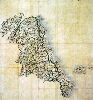
Latter 1800s? - Map of Gangwon Province, Ulleungdo, and Its Neigboring Island Usando

The map to the left shows Korea's Gangwon Province and the island of Ulleungdo (鬱陵島) with its neighboring island of Usando (于山). The map is stored in the Hye-jong Museum of Korea's Gyeonghui University.

The date of the map is listed as unknown, but the map resembles other Korean maps made in the late 1800s. The shape of Ulleungdo's neighboring island of Usando, for example, is similar in shape to THIS MAP, which was made sometime between 1888 and 1895.

One of the difference between the two maps is that the 1888-1995 map shows Ulleungdo with six neighboring islands, and this map shows it with only four.

Below is the portion of the map showing Ulleungdo with its neighboring island of Usan (于山). Usando (于山島) was the old name for Ulleungdo's neighboring island of Jukdo, which is about 2 kilometers off Ulleungdo's east shore.
 
 
Notice that the shape of Ulleungdo's neighboring island of "Usan" (于山) on the above map is very similar to the shape of Ulleungdo's neighboring island of "Jukdo" (竹島) on Lee Gyu-won's 1882 survey map of Ulleungdo below. This is one reason I think the above map may have been made sometime after Lee's 1882 inspection.

23.9.12

1882 - Lee Gyu-won's Survey Map of "Outer Ulleungdo (鬱陵島外圖 - 울릉도외도)

Mr. Tanaka Kunitaka has posted a great copy of Ulleungdo Inspector Lee Gyu-won's (李奎遠) 1882 survey map of Ulleungdo entitled "Outer Ulleungdo" (鬱陵島外圖 - 울릉도외도), which shows Ulleungdo's neighboring islands,  rocky islets, and shoreline. Inspector Lee also made a separate map of "Inner Ulleungdo" (鬱陵島內圖 - 울릉도내도), which shows an interior valley labeled "Nari-dong" (羅里洞 - 나리동), also called Guk-dong (國洞 - 국동), and 14 surrounding moutain peaks that jut outward on the map, which caused some to describe the island as being pot-shaped.

Inspector Lee left on his 1882 mission expecting to find Ulleungdo with one neighboring island called "Songjukdo" (松竹島 - 송죽도), which he had heard was 1.2 to 4 km offshore. Instead, he found two neighboring islands, one named "Jukdo" (竹島 - 죽도) and the othere named "Dohang" (島項 - 도항).

Just prior to the 1882 mission both King Kojong and Inspector Lee said HERE that "Songjukdo" (松竹島 was sometimes called "Songdo" (松島 - 송도) and sometimes called "Jukdo" (竹島 - 죽도), so apparently the name "Jukdo" was being used by visitors to the island at the time. In 1870, a Japanese mission to Korea reported HERE that they had heard that Ulleungdo had a neighboring island called "Matsushima" (松島), which is the Japanese pronunciation for "Songdo." Today, Ulleungdo's neighboring island of "Jukdo" is just 2 km off Ulleungdo's east shore.

King Kojong had also asked Inspector Lee to search for a neighboring island named "Usando" (于山島 - 우산도), but Inspector Lee was unable to find an island by that name. The reason was that Usando was just another name for Ulleungdo's neighboring island of Jukdo, which Ulleungdo Inspector Bak Seok-chang labeled as "Usando" on his 1711 survey map of Ulleungdo HERE.

If you look closely at the "Outer Ulleungdo" map, you should see a faint red line that probably traced the trails taken by Lee Gyu-won as he explored the island. They show that he either entered or existed the island at four different places: "Japanese Boat Dock" (倭船艙) on the northeast, ,  "Dobang-cheong" (道方廳) on the southeast,  "Tong-gumi" (桶邱尾) on the southwest, and "Daehwangto-gumi" (大黃土邱尾) on the northwest. The "Inner Ulleungdo" map also shows a red line.

"Outer Ulleungdo" (鬱陵島外圖)


Inner Ulleungdo (鬱陵島內圖)


19.9.12

2007 Mar 19 - Dokdo Museum Director Admits Usando (于山島) on Korean Maps Ulleungdo's "Jukdo, not Dokdo"

In the March 3, 2007 article below, the online version of the Korean newspaper Daegu Ilbo reported that Dokdo Museum Director Lee Seung-jin confirmed that the island labeled "Usando" (于山島 - 우산도) on three Korean antique maps appearing in this post was Ulleungdo's neighboring island of "Jukdo" (竹島 - 죽도), which is about 2 kilometers off Ulleungdo's east shore. He added that it was not "Dokdo" (獨島 - 독도), which is about 90 kilometers to the southeast of Ulleungdo. "Dokdo" is the Korean name for Liancourt Rocks, which the Japanese refer to as "Takeshima" (竹島).

The Korean name for Ulleungdo's neighboring island of "Jukdo" (竹島) and the Japanese name for Liancourt Rocks, "Takeshima" (竹島) both use the same Chinese characters, which has caused some to confuse the Korean island of Jukdo with the Japanese island of Takeshima.

However, in spite of admitting that the Usando (于山島) on the Korean maps was Ulleungdo's neighboring island of Jukdo, the Dokdo Museum Director claimed "the Japanese were trying to cover up their forced claims" by showing closeups of the island on maps instead of the full map, which would not have shown any detail in the newspaper article. He also still claimed that Usando was one of the old Korean names for Liancourt Rocks (Dokdo), though he provided no evidence to support the claim.

The map above is Ulleungdo Inspector Bak Seok-chang's 1711 inspection map of Ulleungdo (鬱陵島圖形). The two maps below, respectively, are Kim Jong-ho's 1834 map of Ulleungdo from his atlas "Cheonggudo" (靑邱圖) and a cut-out from the Gangwon Province (江原道) map from the 1789-1795 Korean atlas  "Yeojido (輿地圖). These three maps are the maps that the head of Korea's Dokdo Museum on Ulleungdo said showed Ulleungdo's neighboring island of Jukdo (2km offshore) labeled as "Usando" (于山島 - 우산도). He added it was not "Dokdo" (獨島 - 독도), which is the Korean name for Liancourt Rocks, about 90 kilometers southeast of Ulleungdo.

The reason I am reposting this article is that the link I posted to the Korean newspaper article online is, for some reason, no longer working. Fortunately, I had saved a screenshot of it.
Dokdo Museum Head: "It's just Jukdo"
Japanese Media “Discovery of Old Map Refutes Dokdo Territorial Claims”
Japan’s Kyoto News Agency and Tottori Prefecture’s “San-in Chuo Simpo” have recently reported, “Old Korean maps have been discovered that refute Korea’s territorial claims on Dokdo.” The “San-in Chuo Simpo” reported on its Web site on the 22nd of last month that American Gerry Bevers (51), who works as an English professor at a college in Seoul and studies the Dokdo problem, had contributed old maps that refuted Korea’s territorial claims on Dokdo. 
The contributed data were pictures of three old maps of Ulleungdo that are stored in Seoul National University’s “Gyujanggak” museum. When contributing the old maps, Mr. Bevers said, “Dokdo was not written on any Korean documents or maps before the Japan government incorporated Takeshima in 1905.” He added, “The Korean side claims that the old name for Dokdo on old maps and in old documents was ‘Usanguk.’” 
Takashi Tsukamoto, advisor at Japan’s National Diet Library, claimed, “This is a new discovery that only someone living in Korea can research.” He added, “Especially, the map with the writing “haejang bamboo fields” is enough proof to show that ‘Usan’ was not Dokdo.” 
Concerning this, the Northeast Asian History Foundation submitted a statement that refuted the claims item by item. 
The Northeast Asian History Foundation said, “The contents of the maps indicated are all known by both domestic and Japanese scholars, but by saying that the date of the map is unknown and by showing only part of the maps, the Japanese side is scheming to make it seem as if the maps were newly discovered. 
Dokdo Museum Director Lee Seung-jin said, “After confirming the three old maps, it is obvious to anyone that they showed Jukdo, not Dokdo; and even in our country’s academic circles, it is judged to be Jukdo. By not showing the complete map and by showing only an enlarged section, they are trying to cover up their forced claims.” 
In our country, Dokdo has been called “Usando” (于山島, 1432) – “Sambongdo” (三峰島, 1476) – “Jasando” (子山島, 1696) – “Seokdo” (石島, Korean Imperial Edict 41), and Dokdo (獨島, 1904). 
Ulleung = Reporter Lee Jae-hun ljh@idaegu.com


18.9.12

1950 Mar 30 - "Korea's Recent Claim To The Island of Tsushima," OIR Report No. 4900

The following March 30, 1950 report entitled "Korea's Recent Claim to the Island of Tsushima" was prepared by the Division of Research for Far East in the Office of Intelligence Research (OIR) of the United States Department of State. The report essentially says that Korean post-war (WWII) claims of sovereignty over the Japanese island of Tsushima were groundless and seemed to have been based on an appeal to nationalism and anti-Japanese feeling in Korea.

The report mentions Korean President Rhee Syngman's claiming that Tsushima was originally Korean territory and that "In the heart of every Korean is a longing for the return of those islands." That emotional appeal sounds very similar to the emotional appeals many Koreans make today in regard to Liancourt Rocks (Dokdo), which Koreans also claimed after the war without providing any evidence to back up their claim.

After the war, Korea seems to have tried to take advantage of Japan's defeat by making emotional claims to Japanese territory, including Liancourt Rocks, hoping that the the United States and its allies would simply give Korea the Japanese territory it wanted without checking the facts of the claims. Well, it appears Korea misjudged the United States.

ABSTRACT  
On several occasions since the establishment of the Republic of Korea, the Koreans have indicated that they might present a claim to the Japanese island of Tsushima, apparently on the basis of the historical relationship between Korea and Tsushima. However, a note of caution in their latest statements may indicate that they have increasting doubts as to their chances of succsess and that they no longer intend to press the claim. Korea apparently held a dominant position on the island before 500 A.D., but its claim to control in subsequent periods is not supported by the facts available. On the contrary, there is little doubt that during the last 350 years Japan has exercised complete and effective control over Tsushima.  
KOREA'S RECENT CLAIM TO THE ISLAND OF TSUSHIMA

Recent Korean Statements Regarding Tsushima
 The island of Tsushima (1) has been recognized for many years by the commnity of nations as an integral part of the Japanese homeland. It was included in the territory placed under the Allied Military Occupation in 1945 instead of being detached from the Japanese Empire as conquered territory subject to future settlement at the peace conference. After the establishment of the Republic of Korea in 1948, however, Koreans began to demand Tsushima be taken from Jaapan and returned to them.
The Korean demands to date do not consitute a formal claim to sovereignty; they are, rather, declarations of future intentions and desires. The first statement on the issue was made by President RHEE Syngman on August 17, 1948, when he said, "In the heart of every Korean is a longing for the return of those islands," and indicated taht this would be the only demand for territory made by his government against Japan. The Japanese Prime Minister immediately denied the validity of any Korean claim, and heated words were exchanged by the Korean and Japanese press. The Korean demand was stated again in a petition sent to the Supreme Commander for the Allied Powers in late 1948 by the Old Men's Patriotic Association of Seoul, a minor right-wing political organization.
________________ 
  1. "The island of Tsushima" consists of (1) a single large island, about 70 miles long and 10 to 15 miles wide, that is divided into two major segments by small canals and (2) several minor islands. It is situated at the southern entrance to the Sea of Japan, approximately 27 nautical miles from the coast of Korea and 45 from Kyushu.

(Page) 2
President Rhee reiterated his demand on January 7, 1949 with the statement, "Tsushima was not robbed by Japan in the past forty year, but nevertheless the island originally belongs to our country and its return should be demanded. (1) The question was taken up by the National Assembly on March 22, when Assemblyman YI Kunwon introduced a resolution calling for the return of Tsushima to Korea. The motion was shelved after a brief examination by a subcommittee. When Rhee was questioned in a press conference on December 30, 1949 as to the advisability of sending "a research group" to the island, "in order to certify historically that Tshusimaa [cic] island belongs to the Republic of Korea," he replied that this was a problem for the Japanese peace conference and that premature discussion of it might prejudice Korean relations with other countries. (2)

While many Koreans may be convinced of the validity of the claim, it is obvious that the government's demands and popular support for them have not been based on a rational, legal analysis of the issue. The demands appear to be both a reflection of and calculated appeal to the nationalism and the anti-Japanese feelings that prevail throughout the Republic. They may also represent an attempt by the government to extract some small concessions from the Allied Powers. Public reaction to these demands has been generally favorable, but there has been some open ridicule of them and there has been little natural interest in or support of them except from such small segment of the population as the
_____________________ 
  1. RBIS, Daily Report (For Eastern Section, 5, January 12 1949, p. 444 - 7, UNCLASSIFIED.
  2. A-463, Seoul, December 31, 1949, RESTRICTED.

(Page) 3 
nationalist historicans. The lack of extensive public interest and a more dispassionate analysis by the government of its chances for success probably account for the prolonged silence following the first show of interest. The President's cautious statement of December 30, 1949, to the effect that pressing the claim could produce a conflict of interests with other nations, appear to indicate that the government has made a rational reaappraisal of its entire position in the matter. The American Embassy in Seoul is of the opinion that the government now realizes the inability of proving its case and will no longer press the claim. (1)
TSUSHIMA'S PAST RELATIONS WITH KOREA AND JAPAN (2)
The Korean demands for Tsushima have been based on the assumption that  Korea exercised genuine control over the island at some time in the past. Thus far, however, no attempts have been made to define the period of control and no reasons have been advanced for the loss of the island.
There are several important qualifications to be taken into consideration in any discussion of the evidence on the questioni of Korea's relations with Tsushima. First, the information available is far from complete, except for the most recent periods. (3) Second, it is difficult to define these relationships precisely in Western political
______________________
  1. D-93, Seoul, January 25, 1950, RESTRICTED.
  2. See appended historical bibliography.
  3. Almost no original source material is available. The sources that are available are vaue, confusing, and limited in scope; there are notable discrepancies in the reporting of alleged facts. Much more American and Japanese source material is available than Korean, and as a consequence the Korean position may be underestimated. 
(Page) 4
terminology because of the difference between Western and Oriental theories of interstate and inter-area relations. For example, under Korean Confucian and Japanese concepts of control several nations migh possess approximately similar political rights within the same area; such concepts obviously cannot be described by use of such Western terms as "dependence," "independence," "sovereignty," or "suserainty." However, despite these confusing factors, it is possible to make a reasonally accurate comparison of the relative degrees of Korean and Japanese control on the island. 
Korean realtions with Tsushima have varied significantly in the past and can best be discussed in terms of four historical periods. The earliest of these periods is the era of the Korean kingdom of Silla's predominence on the island, which ended c. 500 A.D. The period extends to 1592, when Japan launched the first of a series of major invasions against Korea from Tsushima. The extends to 1855, the date of teh Meiji Restoration in Japan. The fourth and final period includes the years from 1868 to the present.

Most sources agree that in the first period the Korean kingdom of Silla (1) governed the island for a long but indefinite period of time. There is also some evidence that Silla's control was terminated by the Japanese seizure of the island in approximately 500 A.D. 
 There is no such unanimity of opinion as to the relationship between the island and the Korean peninsula during the years from c. 500 to 1592. Some of he texts allege that
______________________
  1. An ancient state whose lands now consitute the southeast territory of the Republic.

(Page) 5

Korean influence was still paramount; references are made to the investiture of the rulers of Tsushima with titles and seals by the King of Korea, and it is claimed that the King of Korea paid subsidies to the island lord, who, in return, paid tribute and homage to Korea. However, the great number of invasions of the island by Korea during this period casts some doubt on Korea's ability to maintain control there for any appreciable length of time, even at the cost of war. Similar allegations of paramountcy are made on behalf of Japan in other works. However, the role claimed for Japan required greater activity on its part and a greater degree of control over island affairs, and this evidence accords better with the known facts of Tsushima history. The very fact that the Japanese invasion of Korea in 1592 was launced in part from the island presupposes effective Japanese control. 
For the period from 1592 to 1668 there is very little specific evidence that Korea exercised any control on the island. Even the texts that affirm belief in the existence of Korean rights of overlordship offer little information to prove that these rights were ever exercised in open and direct interention in island affairs. On the other hand, there is considerable evidence that Japanese control was complete and open and that it was peaceful, i.e., that both Korea and Tsushima acquiesced in, and willingly acknowledged, this state of affairs and no other nation challenged it. Japan appears to have been the de facto ruling power at this time.

There is no question of Tsushima's status as a dependency of Japan after 1668.
 
(Page) 6

The Japanese reorganization of the government of Tsushima following the Meiji Restoration antagonized the Koreans, but they could only express disapproval of it. No other nation has sought to challengde Japan's control since 1668. 
Therefore, from the information available, Korea's claim does not appear to be well-founded. Although Korea apparentlyy held a dominant position on the island before 500 A.D., its claim to control in subsequent periods is not supported by the facts available. On the contrary, there is little doubt that during at least 350 years Japan has exercised complete and effective control of Tsushima.


1973 Jun 16 - "Dong-a Ilbo" Questions the Discovery of "Parang Island"

This June 16, 1973 article in the Korean newspaper Dong-a Ilbo has helped answer a very important question for me. Who told the Korean government that Liancourt Rocks was Korean territory?

Well, according to Yu Jin-o ((洪鍾仁), who was quoted in the article, the Korean Prime Minister at the time told him that Korean President Rhee Syng-man had tasked him with finding out the boundaries of Korean territory. The Korean Prime Minister said the Korean President recommended that he go to Korean historians for the answers. As a result, the Prime Minister went to the renowned Korean historian Choi Nam-seon (崔南善), who told him that old Korean texts recorded that Korea's easternmost boundry was "Dokdo" (獨島) and its southwestern boundary was Parangseo (波浪嶼).

The problem with going to Mr. Choi Nam-seon for help in determining Korea's boundaries is that Mr. Choi wrote in his  1948 book "General Knowledge of Joseon" (朝鮮常識) that Korea's easternmost boundary was Ulleungdo's neighboring island of "Jukdo" (竹島), which is only 2 kilometers off Ulleungdo's east shore. Here is what Mr. Choi wrote in 1948: (LINK):
Easternmost (極東)
130º 56 min 56 sec East Longitude (東経130度56分23秒)
 [Ulleungdo''s Jukdo in North Gyeongsang Province (慶尚北道鬱陵島竹島)]
I think Mr. Choi Nam-seon mistook Ulleungdo's neighboring island of "Jukdo" (竹島), which is only 2 km off Ulleungdo's east shore, for Japan's "Takeshima" (竹島), which is about 90 km to the southeast of Ulleungdo, because both names used the same Chinese characters: 竹島. And I think Korea's Patriotic Old Men's Association made the same mistake. In fact, Choi Nam-seon may have even been one of those Patriotic Old Men.

Here is my translation of the June 16, 1973 article.
Events Leading to a  Citizen of Jeju Province Applying for an Occupation Permit 
"In Science there are no miracles. We are at sea at coordinates 32º 10' N and 125º E. Within the twenty mile range of visibility, Parang Island cannot be detected."
In August 1951 Mr. Hong Jong-in (洪鍾仁), the head of the research team sent to find Parang Island in the sea 180 kilometers (km) to the southwest of Jejudo, sent the above cable to Son Won-il (孫元一), the Chief of Naval Operations. At the time Mr. Hong was the chairman of the Korean Alpine Club and editor-in-chief of the Chosun Ilbo. 
When the United States and Japan were making the first draft of the San Francisco Peace Treaty, the research team sent to find Parang Island, with the help of the navy, searched the waters 180 km southwest of Jejudo, but, in the end, were unable to find it.
Is "Parang Island" really an island?
The question of this unconfirmed island has once again been brought up by Han Gwang-seop 韓光燮), a resident of Jeju Province. He claims to have confirmed the island and has applied to Jeju provincial authorities for a permit of occupation. (Refer to the article on Page 7 of the Donga Ilbo.) 
For now, Jeju authorities have returned his application, giving the reason, "It shows up as a reef on navigational charts and is outside our territory." However, the question is whether it is really an island coming up out of the sea at that location or whether it is part of the contiental shelf. If it is part of the continental shelf, then how it will be treated under international law becomes a question of interest. 
Han Gwang-seop said, "Navigational charts show that spot labeled only as as "current breaks." It is obvious that it is not an island above the surface of the water." According to the (Geneva) Convention on the Law of the Sea, 'An island is a natural area that is surrounded by water and sticks up out of the water at high tide.' It defines an area that naturally sticks up above the water at low tide but is submerged at high tide as an 'elevated area.' If an elevated area is outside territorial waters, it cannot have its own territorial waters."
 In 1951 the naval vessel ordered by President Rhee to do the first on-site search ended up not finding it. 
If it is submerged at high tide, it is not an island.
If it is part of the continental shelf, it becomes a problem dealt with under international law, which would generate a lot of interest.
Constitutional Law scholar Yu Jin-o (兪鎭午) explains the 1951 search for this island as follows:  
At the time of the evacuation to Busan, I went to see Prime Minister Jang Myeon (張勉), who said he had been instructed by the President to find the borders of our territory. He was told to prepare for Korea-Japan talks by first meeting with historians. Therefore, he met Choi Nam-seon (崔南善), who told him that old texts recorded our territory as Dokdo (獨島) to the east and Parangseo (波浪嶼) to the southwest, so he said we should do an on-site survey. Hong Jong-il (洪鍾仁) was made the team leader, and a naval survey team was sent to the site, but they were unable to find the island in the end.
Misters Yu Jin-o (兪鎭午) and Hong Jong-in (洪鍾仁) said that if it is only a reef and not an island, then it cannot be a territorial issue or be subject to administration with an occupation permit under international law, but if it can be confirmed as an island, then we could argue that our territory should be extended out to there. An official of the Ministry of Foreign Affairs also said on the 19th, "If it submerges at high tide and appears at low tide, it is an elevated area that is not recognized as an island under international law, and a place like that cannot be the object of possession."

The experts say that the issue with Parang Island is still unconfirmed, and even if it is confirmed, it will still remain open seas if it is a reef and not be a territorial issue.
 
Reporter Kim Jin-bae (金珍培)

17.9.12

1973 Jun 16 - Korean newspaper "Maeil Gyeongje Sinmun" Reports the Discovery of "Parangseo" (坡浪嶼)

In an August 5, 1948 letter of petition to General Douglas MacArthur, a Korean organization known as the Patriotic Old Men's Association claimed that a "series of islands" named "Parangdo" belonged to Korea, but in spite of listing coordinates for the islands and giving distances to them HERE, no one could find them, so Korea dropped its claim.

However, in the following June 16, 1973 article, the Korean newspaper Maeil Gyeongje Sinmun reported the discovery of two newly discovered islands 177.6 kilometers to the southwest of Jeju Island (濟州島). The Korean man who discovered them named them "Parangseo" (파랑서) and "Harangseo" (하랑서).

The article gives the area of the small rock islands as being millions of square meters, which does not seem very small to me, so I suspect he was giving the dimensions as 520m x 392m. That would be a total area of 203,840 sq. meters. (Info in Korean language)
Two Uninhabited Islands Discovered Southwest of Jejudo 
In the open sea 177.6 kilometers to the southwest of Jejudo, two uninhabited islands have been discovered for the first time. The man who discovered them is Han Gwang-seop (韓光燮), who lives in Jeju Province. On the 15th he submitted an application for a permit to occupy waters on the open seas.
 
The two islands are 177.6 kilometers southwest of our southernmost island of Marado (마라도) at 32º 10' N and 125º E in the East China Sea. They are just small, rocky islands. The area of one is 5.2 million sq. meters, and the area of the other is 3.92 million sq. meters.

Mr. Han has named the islands "Parangseo" (파랑서) and "Harangseo" (하랑서). On sea charts they are listed as a reef.

1948 Aug 5 - Petition Concerning Sovereinty of "Docksum" by the Patriotic Old Men's Association (憂國老人會)

A group of Koreans who referred to themselves as the Patriotic Old Men's Association (憂國老人會), headquarted in Seoul, Korea, sent a 6-page petition letter dated August 5, 1948 to General Douglas MacArthur, the Supreme Commander for the Allied Powers (SCAP), claiming Korean sovereignty over "Docksom," Ulleungdo, Tsushma, and "Parang" Islands. The letter was apparently received by or transferred to  the US Political Adviser for Japan because carbon copies were made and sent to the US Representative in Seoul with a September 16 cover letter explaining the Korea petition. The cover letter and the 6-page Korean petition are posted below.

Notice in their claim for "Docksum" (Liancourt Rocks) that they wrote that the Korean name meant "pot island" and that it was given that name because it looked like a pot. Apparently, the Patriotic Old Men never saw Liancourt Rocks because they look nothing like a pot. The name "Dokdo" (獨島) actually means "Lonely Island."

The Patriotic Old Men seem to have thought Liancourt Rocks was a reference to either Ulleungdo or Ulleungdo's neighboring island of Jukdo (竹島), which is just two kilometers off Ulleungdo's east shore. Not only does Ulleungdo's neighboring island of Jukdo look more like a "pot" than Liancourt Rocks, the name "Jukdo" (竹島) uses the same Chinese characters as the Japanese name for Liancourt Rocks, "Takeshima" (竹島). The fact that the same Chinese characters were used for both islands is probably the source for the misunderstanding. The Patriotic Old Men must have thought the Japanese were trying to claim Ulleungdo and its neighboring of Jukdo.

As for their claim to Parangdo, the Patriotic Old Men seemed to think they were a "series of islands," instead of an underwater reef. An October 22, 1947 article in the Korean newspaper Dong-a Ilbo HERE talks about a "cluster of islands" called "Parangseo" (坡浪嶼); nevertheless, no one could find the islands, so Korea ended up dropping its demand they be included in the Peace Treaty. It was not until 1973 that a Korean man named Han Gwang-seop (韓光燮) found the islands "for the first time." (See HERE.)


1947 Oct 22 - "Dong-a Ilbo" Reports Japan's Claim to "Parangseo" (坡浪嶼)


In an October 22, 1947 article, the Korean newspaper Dong-a Ilbo reported that Japan had told the MacArthur Command that the Yellow Sea islet of "Parangseo" (坡浪嶼) was Japanese territory. Parangseo is actually an underwater reef that is now called Ieodo (離於島 - 이어도) in Korea and Socotra Rock in Western countries. (Wikipedia)

The article claims that the Japanese had the MacArthur Line drawn to include Socotra Rock on the Japanese side, but I think it is possible that the Koreans simply assumed that from maps showing the MacArthur Line.

Notice in the article below that Korea thought Parangseo was a "cluster of islands" (한 무리의 섬), suggesting that it did not know it was really an underwater reef. In spite of giving the distances to the "islands" and their coordinates, Koreans could not find them and withdrew their demand that they be included in the 1952 Treaty of Peace with Japan. It was not until 1973 that a Korean man from Jeju Province named Han Gwang-seop (韓光燮) found the underwater reef. (See HERE and HERE.
Again Showing its Desire for Invasion,  Japan Has Reported to the MacArthur Command that the Yellow Sea Islet of Parangseo (坡浪嶼) Is Japanese Territory 
Unable to rid itself of its invasion mentality, the Japanese pirates are not only scheming to encroach on our East Sea island of Dokdo, as reported several times previously, they are once again infuriating us by now extending their ambitous scheming to the waters of the southern Yellow Sea. The problematic island is Parangseo (坡浪嶼), a cluster of islands located in the Yellow Sea at 32º 30' N and 125º E. 
The island is located 150 kilometers (kms) from Jejudo (濟州島), 290 kms from Mokpo, 450 kms from Nagasaki (長崎), and 320 kms from Shanghai (上海). Just looking at it geographically, the island is without question in our territory. 
Recently, the Japanese government petitioned the MacArthur Command to divide up the region of the Yellow Sea in a way favorable to them. The islands of Parang were placed within the so-called MacArthur Line, meaning they are part of their territory. However, besides being the only spawning area in the South Sea, it is also a large fishing grounds.


日本の侵略的野欲 今度は黄海 坡浪嶼に自己の領土とマッカーサー司令に報告

1947.10.22 東亜日報

 侵略根性を捨て切れない倭寇が東海の海において我々の関土である獨島を侵犯しようとする魔手を止めようとしていないことは再三報じたところだが、今度はまたしても南方の黄海の海にまでも野欲の魔手を伸ばし、新たに我々の感情を激昂させている。
 問題の島は、黄海上の北緯32度30分東経125度にある坡浪嶼という一群の島で、この島は済州島から150km、木浦から290km、日本の長崎から450km、上海から320kmの地点にあり、地理学上から見ただけでも当然に我々の版図に属することは二言を要しないことで、先般、日本政府は黄海の海を区域別に分けて自分たちに有利な条件を付けてマッカーサー司令部に報告し、この坡浪島嶼をいわゆる「マッカーサーライン」内に入れて自分たちの領土だと称しているのだ。
 なお、この島は南海に唯一の海産物の生殖地であると共に一大漁場でもある。

12.9.12

1735 Jan 19 - Disccusion on Delaying Ulleungdo Inspection - Confirms Usando (于山島) a Neighboring Island

This account is from the records of the Border Defense Council of Joseon (備邊司 - 비변사). The record is interesting in that it not only confirms that Usando (于山島) was a neighboring island of Ulleungdo, but also that the policy of inspecting Ulleungdo every three years was diligently followed, though a request to postpone the inspection in 1734 was granted HERE. There is a brief mention of this discussion in the "Annals of King Yeong Jo" (英祖) HERE.

This record is also mentioned by Kim Jong-ho (金正浩) on his 1834 "Cheonggudo" (靑邱圖) map, where he wrote the following next to Ulleungdo's neighboring island of Usando (于山島): LINK TO MAP
“In the 11th year of Yeongjo (1735), Gangwon Provincial Governor Jo Choi-su reported to the king, ‘A survey of Ulleungdo has found that the land is wide and fertile, and there are signs that people have lived there. Also, to its west is Usando, which is also wide and spacious.’ The so-called “west” character is different on this map, where (Usando) is to the east.”
You may notice in the record below, however, that instead of Gangwon Provincial Governor Jo Choi-su (趙最壽) describing Ulleungdo and its neighboring island of Usando, it looks like it was Haeng Jwachamchan Kim Chui-no  (行 左參贊) who described them.

----------------------------
Another Petition: Gangwon Governor Jo Choi-su (趙最壽) says, "I am charged with conducting the Ulleungdo (鬱陵島) inspection this year, but the harvest in the province was extremely bad and unavoidable. There are a variety of goods needed for the trip. All the men dispatched, including the commander and the Japanese interpreter, must be cared for. There are many. The cost required while they wait several months for calm winds cannot be adequately accounted for in this year of poor harvest. Many disturbances are expected. I respectfully ask that the mission be postponed this year, and that we wait for a year of abundant harvest to conduct it."

"This year the harvest in Gwandong (Gangwon Province) was, indeed, bad. Providing provisions for many men while they wait several months for calm winds is, indeed, a hardship, but the policy is that it be done once every three years. Already, it was not conducted last year. If it is postponed again this year, it will be the first time to go against policy; nevertheless, by what means do we do it?" 
The King asked, "How do we do this mission? 
Haeng Jwachamchan (左參贊) Kim Chui-ro (金取魯) said, "Between 1697 and 1698 the Royal Court sent Jang Han-sang (張漢相) to make a detailed survey map and return. And I have heard that Ulleungdo is very broad and fertile. Moreover, there are signs that people have lived there. And, to its west is Usando (于山島), which is also said to be wide and spacious. Since then, the policy of one inspection every three years has been followed. This instance of two years of consecutive postponements is different. The officials defending our coast should be admonished and warned that it is wrong to use the hardships of the province's poor harvest to neglect one's duty every year."

Hojopanseo (戶曹判書) Lee Jeong-je (李廷濟) said, "Back during 1697, the Japanese requested we give them Ulleungdo, but the Royal Court back then vehemently admonished them, denied their request, and sent Jang Han-sang (張漢相) to go look at the island. Ever since there has been a policy of going once every three years. This province's poor harvest is definitely something to consider, but neglecting this mission year after year is also serious because it can cause anxiety.
The King said, "What you both say is correct. Waiting for calm winds, even though a hardship, results in fears of crossing the sea and not wanting to go see it. We cannot allow the neglecting of this land to become commonplace. How can we not send someone into there? I think we must conduct the survey this year. It is permissable to assign it to several people.
----------------------------
又所啓, 江原監司趙最壽狀啓, 鬱陵島搜討, 今年當擧行, 而道內農事不免慘凶, 往來時所入雜物, 皆出民間, 營將及倭學等, 所率甚多, 累朔候風, 所費不貲, 當此荒年, 必多騷擾, 今年姑爲停止, 待年豐擧行事陳請矣, 今年關東年事, 果爲凶歉, 多人治送, 累朔候風, 不無弊端, 而此是定式以三年一往者也, 昨年旣不得擧行, 今年又爲停止, 則雖無當初定式之意, 何以爲之, 上曰, 此事何如, 行左參贊金取魯曰, 丁丑·戊寅年間朝家送張漢相, 看審圖形以來, 而聞 鬱陵島, 廣闊土沃, 曾有人居基址, 或有往來之痕, 其西又有于山島, 而亦且廣闊云矣, 其後仍有三年一搜討之定式, 此與年例操停止有異, 事係海防申飭, 恐不當以本道凶歉些少弊端, 每年停廢矣, 戶曹判書李廷濟曰, 往在丁丑年間, 倭人請得鬱陵島, 故朝家嚴飭不許, 而使張漢相往見此島, 三年一往仍爲定式矣, 本道凶荒, 固爲可念, 而此事之每每停廢, 亦甚可悶矣, 上曰, 兩重臣所達是矣, 候風雖有弊, 而此蓋憚於越海不欲往見之致也, 此地若棄之則已, 不然, 豈可不爲入送耶, 今年則搜討事擧行之意, 分付可也


1735 Jan 13 - Gangwon Governor's Request to Cancel Ulleungdo Inspection Rejected

This record comes from the Annals of King Yeong Jo (英祖). A more detailed discussion of the petition can be found HERE.

----------------------
Gangwon Governor Jo Choi-su (趙最壽) said, "I am charged with conducting the Ulleungdo inspection this year, but we are suffering a bad harvest year, so I request that it be canceled."

Kim Chui-ro (金取魯) and others said, "Back in 1697 the Japanese wanted this island. The Royal Court vehemently rebuked them and sent Jang Han-sang ((張漢相) to map it and return. It was decided to go once every three years, so it cannot be canceled."

The King agreed.

----------------------
 
강원도 감사 조최수(趙最壽)가 아뢰기를,

“울릉도(鬱陵島)의 수색 토벌을 금년에 마땅히 해야 하지만 흉년에 폐단이 있으니, 청컨대 이를 정지하도록 하소서.”

하였는데, 김취로(金取魯) 등이 말하기를,

“지난 정축년 (1697) 에 왜인들이 이 섬을 달라고 청하자, 조정에서 엄하게 배척하고 장한상(張漢相)을 보내어 그 섬의 모양을 그려서 왔으며, 3년에 한번씩 가 보기로 정하였으니, 이를 정지할 수가 없습니다.”

하니, 임금이 이를 옳게 여겼다.

 
江原監司趙最壽啓言: “鬱陵島搜討, 今年當行, 而歉歲有弊, 請停之。” 金取魯等曰: “往在丁丑, 倭人請得此島, 朝家嚴斥, 而遣張漢相, 圖形以來, 定以三年一往, 不可停也。” 上可之。

11.9.12

1734 Jan 15 - Gangwon Governor Asks to Postpone Ulleungdo Inspection

"This comes from the records of the Border Defense Council of Joseon (備邊司 - 비변사). It is not really important, but I wanted to translate something short.

------------------
On the same day, Yeongwuijeong (領議政) Sim (沈) goes before the King and  reports, "Gangwon Governor Eo Yu-yong (魚有龍) has petitioned the following:
'Next year is the Ulleungdo inspection, of which I am charged. When conducting the trip, the needed expenses are very many and wide-ranging. Last year several villages in Yeongdong had an especially bad harvest, making it difficult to carry out the orders. I ask that it be postponed for a while?'"
"The situation in this province is, indeed, as he said. Will you grant his request?"
The king replies, "I grant it."

-------------------

同日入侍時, 領議政沈所啓, 江原監司魚有龍狀啓以爲, 鬱陵島搜討明年當此, 而其往來之際各種浮費極爲浩多, 昨年嶺東諸邑凶歉尤甚, 勢難擧行, 姑爲停止云, 本道事狀誠然矣, 依施何如, 上曰, 依爲之。

6.9.12

Koreans Claim Tax Records Prove They Administered Dokdo

Asian News Agency reports in a September 6 article, entitled "Ulleung County Has 'Document Proving Effective Control of Dokdo,'" that an Uldo County record shows that Japanese fishermen paid export taxes on seal lions caught on "Dokdo" (Liancourt Rocks) in 1904. Koreans claim that proves Ulleung County exercised effective control over the island.

The document does not mention where the sea lions were captured, only that taxes were paid on sea lions harvested by Japanese fishermen operating from Ulleungdo. Koreans claim, however, that since Liancourt Rocks was the only place where there were sea lions at the time, the document proves the County had exercised effective control over the Rocks.

Japanese fishermen were fishing Liancourt Rocks from Ulleungdo in the early 1900s, but Liancourt Rocks were not part of Ulleung County, as was confirmed by the Korean Ministry of Interior in 1906.

In a July 13, 1906 Korean newspaper article HERE, the Korean Ministry of Interior defined Ulleung County as being only 24km from east-to-west and 16km from north-to-south. Since Liancourt Rocks is about 90 kilometers southeast of Ulleungdo, that means they were outside the jurisdiction of the County.

If the Japanese fishermen had fished in international waters and brought their catch back to Ulleungdo for processing, they would have had to pay taxes, as well, but that would not make the international waters Korean territory.

Actually, the document might support the Japanese claim to Liancourt Rocks since it seems to be more evidence that Japanese knew of and were fishing the Rocks before they were incorporated into Japanese territory in 1905. Of course, if the document said that Japanese fishermen were fishing at "Seokdo" (石島 - 석도), which Koreans claim was the name of Liancourt Rocks at the time, it might mean something.

1.9.12

1876/77 - Watanabe Kouki's "Opinion on Matsushima - 2"

Watanabe Kouki (渡辺洪基) was the Director of the Bureau of Documents in Japan's Ministry of Foreign Affair in 1876 when he wrote the opinion below on the location of an island referred to as "Matsushima" in a petition by Mutoh Heigaku (武藤平学), who wanted permission to develop the island. The opinion is Director Watanabe's second opinion on the island. His first opinion can be found HERE. Both opinions were included in an 1881 Japanese Ministry report entitled "A Study of Historical Evidence of Takeshima" (竹島考証).

The Japanese Foreign Ministry was confused as to the location of the Matsushima mentioned in Mutoh Heigaku's petition not only because the island described sounded similar to the Korean island of Ulleungdo, which the Japanese referred to as Takeshima, but also because Matsushima was the name of an island near Japan's Oki Island that the Japanese referred to as "Oki's Matsushima" (隱岐ノ松島) and Western maps referred to as either Liancourt Rocks or Hornet Rocks.

Moreover, the British added to the confusion when the captain of the Bristish ship "
HMS Argonaut" lost a rudder near Ulleungdo in 1789 and mismapped Ulleungdo's location as 37º 32' N and and 129º 50 E, resulting in many Western maps showing the non-existent island of "Argonaut" about 109 kilometers to the northwest of the real Ulleungdo, which was referred to by many Western nations as "Dagelet Island." This map confusion lasted through most of the 1800s.


Then in 1840, a map by Philipp Franz Balthasar von Siebold HERE was published that added to he confusion by co-labeling the non-existent island of Argonaut as "Takeshima," which was the Japanese name for Ulleungdo, and the real Ulleungdo as "Matsushima," which was the Japanese name for Liancourt Rocks. Dr. Siebold seems to have mistakenly shifted the names he saw on Japanese maps up from Ulleungdo and Liancourt Rocks to Argonaut and Ulleungdo, respectively.
Opinion on Matsushima - 2 
I have heard that Matsushima (松島) and Takeshima (竹島), called Ulleungdo in Korea, are just two names for the same island. However, I have also heard from the former Governor of Tottori Prefecture that there are, indeed, two islands. According to writings by Toda Takayoshi (戶田敬義), Katou (加藤), and Ken Kanamori (金森謙), there is an island called Takeshima about 40 ri to the north of the West Island (西島) of Oki’s Matsushima (隱岐松島) . [West Island is just a small island of Matsushima that islanders call “Next Island” (次島).] Also, it is said that Takeshima is about 140 ri  by ship from Yonago in Hoki Province (伯州米子). They say that you can sail from Yonago to Izumo (出雲) and then on past Oki’s Matsushima (隠岐松島) to reach Takeshima (Ulleungdo).
However, it is also written that it is about 60 ri by ship from Oki’s Fukushima (福島), also called Fukuura (福浦), to Matsushima, and then about 40 ri from Matsushima to Takeshima. Moreover, it is about 40 ri from Takeshima on to Korea. This is based on the story of an old man who in 1724, the 9th year of Kyoho (享保), testified that he had sailed there several times. When asked he said, “The distance from the village of Mitsuyanagi of Hamanome (濱野目・三柳村) in Aimi County (會見郡) of Hoki Province (伯州) to Oki’s Dogo Island (隠岐ノ後島) is between 35 and 36 ri. Using this distance one can guess the distance from Takeshima to the mountains of Korea to be about 40 ri.” Based on this, there definitely seems to be two islands. 
If we look at Western texts, the British “Imperial Gazetteer” says that Dagelet Island (pronounced as “Dazera”),  that is Matsushima, is an island in the Sea of Japan that is situated between the Japanese Archipelago and the Korean Peninsula. Its northwest corner is at 37º 25' N and 130º 56' E (Greenwich means). It was named by La Pérouse in 1787. It has a coastline of sheer cliffs and is approximately 9 ri around. It is covered by dense forest up to its highest point.Also, “Lippincott’s Pronouncing Gazetteer of the World  says that Dagelet is a small island in the Sea of Japan that is exactly between Japan and Korea. It has a circumference of 8 ri and is positioned at 37º 25' N and 130º 56' E. If you look this up on a map, the location of the island labeled as Dagelet, or Matsushima, on the British Navy’s nauticalchart seems to be at the same position in both books.
The British “Royal Atlas”; the “Atlas Universel,” by Brué of France; “Map of Japan and Korea” by James Wyld, geographer to the British Queen; “Map of Asia” by Kiepert of Germany; 1875 Gotha:  Stieler Atlas”; a map by the Geographische Institu in Weimar all show the island of Dagelet in the same position.It is said an island is drawn with dotted lines, except on the British nautical chart, at 129º 57' E and 37º 50' N and labeled “Argonaut” or “Takeshima.” The island is also clearly shown at the same position on a map of the Russian Mapping Bureau.

Also, in the text of Ken Kanamori (金森謙), it is written that Takeshima has a circumference of 15 ri. Moreover, it you add up all the measurements done by Toda Takayoshi (戶田敬義) 
 on his map, they total about 23 ri. (That includes all the ins and outs of the shoreline.) That circumference is more than just a little different than that of Matsushima, or Dagelet. On the south corner of the map is drawn an island that has a circumference of about 1.5 ri. That island is probably Uindo (于人島) [Uindo (于人島) probably a misspelling of Usando (于山島)].
However, Matsushima and Takeshima are two islands, and since Matsushima is closer to our country than Takeshima, Korea also cannot oppose our saying Matsushima is part of Japan.

And regarding the importance of the island, it is situated almost midway between Japan and Korea. It is on the sea route from our San’in (山陰) region to Korea’s Yeongheung-bu (永興府), namely Port Wonsan, in Hamgyeong Province (咸鏡道
),. When traveling from Nagasaki to Port Vladivostok, one must pass it, which means it is many times more important than Takeshima. Moreover, it has frequently caught the attention of such countries as English and Russia. It is known in this way by several other countries.
 
However, in our country it is unknown if Matsushima and Takeshima are two islands or one. Accordingly, we do not know if it is part of Korea or not. If a foreign country were to ask, we would not know how to answer. If we decide it does belong to our country, we must show obligation to it. If we decide it belongs to Korea, we do not know how foreign countries will react, so we must be careful. We must try reflecting on this point.

Written by Bureau of Documents Director Watanabe Kouki (渡辺洪基)